What to expect
Your safety is your responsibility. Stay safe in the outdoors and follow the five essential steps of the Land Safety Code.
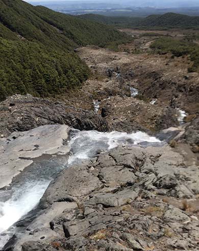
The Cascades are slippery when wet or icy
Image: DOC
On the Round the Mountain Track, be aware that:
- Most of the track is on rugged and exposed alpine terrain, there are just a few sections of forest around the western and southern sides. The lowest altitude of the track is about 1100 m, and the highest (at Rangipo Hut) is close to 1600 m.
- There are some unbridged streams and river crossings, including the two larger rivers - the Whakapapaiti and Mangaturuturu rivers on the western side of Ruapehu. You will need to know how to cross rivers safely.
- Major hazards on the track are generally managed during summer (October to April). In winter the main hazard is snow/ice on the track.
- We recommend you treat stream water to guard against risk of infection from giardia and other bugs.
- All huts need to be booked in advance.
Fill in the visitors' book if you are staying in a hut.
In the peak summer season (October to April), there is a resident warden at Waihohonu Hut, who can give weather and track information or assist should an emergency arise. No other huts have resident wardens, but sometimes rangers are present.
Weather
The weather in Tongariro National Park is often more extreme than other places in the North Island. Be prepared for cold, wet, snowy/icy, or windy weather at any time of year.
Check the weather forecast – NIWA website.
Heavy rain can make the unbridged streams and rivers impassable on this track. Be prepared to wait for water levels to drop. Never cross a flooded river.
Winter conditions
During winter months snow/ice can cover all or parts of the track, and avalanche risk may apply. Walking and/or navigation can become more difficult.
Alpine experience and equipment may be required during this period (crampons, ice axe, possibly avalanche transceiver, shovel and probe).
- Find out more about winter tramping
- Check the webcam on the Geonet website for snow coverage
Avalanches
Avalanches are possible during and after heavy snow falls. Check the avalanche advisory before you leave. If risk applies, carry a transceiver, shovel and probe and know how to use them. If the risk is 'considerable' or above - don't go!
Avalanche terrain ratings in Tongariro National Park
Stay safe when crossing rivers and streams
If you plan to cross unbridged rivers or side streams, know how to cross safely and be prepared for if you cannot cross.
Do not cross if the river or stream is flooded, you cannot find safe entry and exit points or are unsure it’s safe. Turn back or wait for the river to drop. If in doubt, stay out.
NIWA river flow forecasts: View a video of national followed by regional river flows
Fitness and experience
The track is classed as a tramping track suitable for people with reasonable fitness and experience. The track is mostly rough and not well formed; some sections are steep, rocky or muddy. The track however is well marked with signs, poles or markers. There are unbridged stream and river crossings.
You can expect:
- To walk up to 6 hours a day and longer depending on your fitness and trip plan
- To carry a pack of up to 15 kg for 66.2 kms
- For a 4 day trip, to walk up to 16 km per day - plus one longer day
- For a 5 day trip, to walk up to 13 km per day
- Most of the track has a hard, rocky and uneven surface. Forest sections can be muddy following rain.
Volcanic hazards
Mount Ruapehu is an active volcano. Eruptions can happen without warning. The last eruption was on 25 September 2007.
If you are on the mountain when an eruption happens, you could be in danger. Whangaehu and Whakapapaiti river valleys are lahar paths, particularly Whangaehu River on the eastern side of Ruapehu, which is the outlet from the Crater Lake. The track crosses these two valleys so don't linger.
- Know the volcanic risks and what to do in an eruption
- Get the latest volcanic status on the Geonet website and watch for signs of an eruption
 No unauthorised drone use in the national park
Unauthorised use of drones is prohibited. You must have a permit to fly a drone.
DOC does not generally approve permits to fly drones in this national park and we do not recommend you apply for one.