2 km return via same track
Image gallery
About the walk
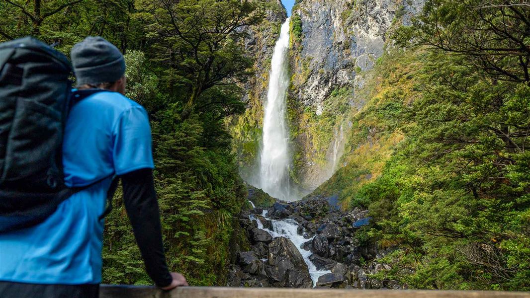
- Spectacular 131-metre waterfall
- Native beech forest and birds
- Steep climb with 400+ steps
Devils Punchbowl Walking Track is signposted from Devils Punchbowl Falls car park. Follow the rough gravel track to the first bridge across the Bealey River. There’s an unbridged stream crossing at Wardens Creek, which can flood in heavy rain.
After a few minutes, a second bridge crosses Devils Punchbowl Creek. You’ll get a good view of Devils Punchbowl Falls/Te Tautea o Hinekakai from here.
The track then climbs steeply up through native mountain beech/tāwhairauriki forest to a viewing platform near the base of the waterfall. When the waterfall is flowing at full force, its spray envelops the platform and the sound is deafening.
Return to the car park the same way you came.
Directions
Arthur’s Pass Village is on SH73 between Christchurch and the West Coast, in the heart of the Southern Alps/Kā Tiritiri o te Moana.
Devils Punchbowl Walking Track is signposted off SH73, at the northern end of Arthur’s Pass Village. It’s on your right as you leave the village towards Hokitika/Greymouth.
Travel times (by car)
- Greymouth (1 hr 30 min)
- Hokitika (1 hr 30 min)
- Christchurch (2 hr 30 min)
Road conditions
Snow can close SH73. Check highway conditions before you travel.
Parking
Devils Punchbowl Falls car park has:
- free parking for cars and campervans
- no marked mobility spaces.
Lock it or lose it
Thieves may target cars parked at Devils Punchbowl Falls car park. Take valuables with you.
Train
TranzAlpine offers a scenic rail journey between Christchurch and Greymouth, stopping at Arthur’s Pass.
Bus
Regular bus services operate between Greymouth or Hokitika and Christchurch via Arthur’s Pass.
Mana whenua
Ngāi Tūāhuriri hold mana whenua or customary authority over this special place.
Safety and hazards
- Steep drops: Parts of the track are narrow and exposed. Stay away from track edges and keep children close.
- Unbridged river crossing: During and after heavy rain, Wardens Creek can flood the track before Bealey River bridge. If it’s flowing fast or looks muddy, it’s not safe to cross.
- Winter conditions: The track gets icy in winter and after snowfall.
When to go
- Arthur’s Pass National Park is an alpine region. Snow, freezing temperatures, strong winds and sunburn are possible in all seasons.
- Devils Punchbowl Falls flows year-round. The waterfall is most spectacular in spring, when snow melts from the Southern Alps/Kā Tiritiri o te Moana.
- Great spotted kiwi/roroa are often heard calling at dusk.
- New Zealand weather changes quickly. Check the weather forecast before you go, and be prepared.
Plan your visit
- Bookings are not required for Devils Punchbowl Walking Track.
- Toilets and an accessible toilet are located at Arthur’s Pass National Park Visitor Centre (5 min by car).
- Drinking water is not available. Bring your own.
- A picnic table and seating are provided along the track, in the clearing after Bealey River bridge.
- Camping is available at Avalanche Creek Shelter Campsite (5 min by car).
- Limited food and petrol options can be found in Arthur’s Pass Village. More services are available in Springfield, Hokitika and Greymouth.
- Mobile phone coverage is unavailable in places.
What to take
- Warm and waterproof clothing
- Sturdy footwear
- Insect repellent
For a complete list, see Short Walks gear list.
Care for nature
- Rubbish bins are not provided. Take your rubbish with you.
- Kea are protected native birds. Do not feed them.
- Dogs can kill kiwi. No dogs are permitted in Arthur’s Park National Park.
Birds
Devils Punchbowl Track passes through dense mountain beech/tāwhairauriki forest that’s rich in native birdlife. You might see or hear:
- rifleman/titipounamu
- bellbird/korimako
- fantail/pīwakawaka
- tomtit/miromiro
- grey warbler/riroriro
- kea.
Great spotted kiwi/roroa
If you’re here at dusk, you might hear great spotted kiwi/roroa calling. Roroa are the largest kiwi species. They only live in the top half of the South Island.
A glacial landscape
Devils Punchbowl Falls/Te Tautea o Hinekakai cascade down from a high glacial valley, called a ‘hanging valley’.
Glaciers sculpted the landscape around Arthur’s Pass and its distinctive U-shaped valleys during the last ice age.
Weaving waters
To Ngāi Tahu, the twining white waters of Devils Punchbowl Falls/Te Tautea o Hinekakai resemble threads of dressed flax (called muka or whītau). Muka is used to weave fine garments and mats.
The falls are named Te Tautea o Hinekakai for the ancestor Hinekakai, a famous weaver. Hinekakai was the wife of Tūrākautahi, a son of Tūāhuriri and the principal Ngāi Tahu chief of his time.
Devils Punchbowl Falls
Devils Punchbowl Falls have been a popular tourist attraction since the coach road from Christchurch to the West Coast via Arthur’s Pass opened in 1866.
Until the early 1900s, only the pool at the foot of the falls was known as the Devils Punchbowl. The waterfall itself used to be called Zealandia Falls.
Nature's in trouble
Thousands of New Zealand’s native species are heading towards extinction. Once they’re gone, they’re gone for good. Nature needs your help.
Arthur's Pass National Park Visitor Centre
| Phone: | +64 3 318 9211 |
| Email: | arthurspassvc@doc.govt.nz |
| Address: | 104 West Coast Road Arthur's Pass 7654 |
| Hours: | Visitor centre hours and services |