
Dog access
No dogs. Other pets on conservation land rules.
Nature's in trouble
Thousands of New Zealand’s native species are heading towards extinction. Once they’re gone, they’re gone for good. Nature needs your help.
State Highway 73, the main road between Greymouth and Christchurch in the South Island, goes right through the park and the village of Arthur’s Pass. Winding in places, it is one of the country’s most scenic routes.
It’s a two hour drive from Christchurch in the east, and about one and half hour’s drive from Greymouth on the west coast. Regular bus services operate between Greymouth, Hokitika and Christchurch. The scenic Tranzalpine Express offers a daily, spectacular train journey between Christchurch and Greymouth, stopping at Arthur’s Pass.
Weather
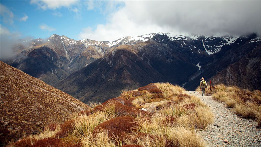
Arthur’s Pass National Park is rugged and mountainous, with weather that can change rapidly with little warning. All visitors should be prepared for wet and cold conditions, even in summer, and for sudden changes in weather. Most tracks involve river crossings - high rainfall causing rivers to rise quickly. Arthur's Pass National Park weather forecast – NIWA website
Avalanches
Avalanches usually occur in Arthur's Pass National Park from May to November. Find out about avalanche danger in Arthur's Pass National Park.
Facilities
For those planning overnight trips, there are many backcountry huts which trampers can use. The tracks are not as developed as they are in other parks and are not continuously marked. Check at the DOC visitor centre for up-to-date information on track conditions.
Thieves targeting cars at Arthur's Pass
There have been reports of cars being broken into and disabled at track ends.
- Don't leave valuables in your vehicle.
- Consider using more public parking sites – ask at the Arthur's Pass Visitor Centre for alternative options.
- Report any suspicious activity to police on +64 3 363 7400.
All drone use must be authorised by DOC
You must have a permit to fly a drone on public conservation land.
Visit our Drone use on conservation land page for more information.
Arthur's Pass National Park is situated between Canterbury and the West Coast in the South Island of New Zealand.
There is a striking difference between the habitats on either side of the main divide. Mountain beech/tawhai dominates eastern slopes. To the west is mixed podocarp rainforest and red-flowering rātā, with a luxuriant understorey of shrubs, ferns and mosses. A historic highway and railway runs through the middle.
Above the bushline, snow tussock and alpine meadows can be seen quite easily on a short walk off the road, at the summit of Arthur’s Pass.
Look out for the kea – alpine parrots famous for their inquisitive nature. The endangered great spotted kiwi/roroa – the ‘mountaineer’ of kiwi – are also found in the park along with more common forest birds like bellbirds/korimako and fantails/pīwakawaka. The open braided rivers of the Waimakariri and Poulter provide nesting grounds for birds such as wrybill/ngutu parore and black-fronted tern/tarapirohe.
Arthur’s Pass was established in 1929. It was New Zealand’s third national park and the first one in the South Island. Jacks Hut is a rare surviving example of a roadman’s cottage. Read about Historic Arthur's Pass.
Arthur's Pass National Park Visitor Centre
| Phone: | +64 3 318 9211 |
| Email: | arthurspassvc@doc.govt.nz |
| Address: | 104 West Coast Road Arthur's Pass 7654 |
| Hours: | Visitor centre hours and services |