- Fitness required: Low
- Gradient: Flat
4.3 km return via same track

No unauthorised drone use in the national park
Recreational drone use is not allowed anywhere in the national park at any time. You must have a permit to fly a drone for commercial purposes on public conservation land. Commercial drone use information.
The track leads through the sacred Tōpuni area of the Hooker Valley, which has special significance and values to Ngāi Tahu iwi.
The track starts at White Horse Hill carpark.
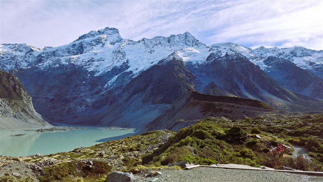
It passes close to the Alpine Memorial (a great viewpoint) and Freda’s Rock, before arriving at Mueller Lake Lookout and a swing bridge.
After crossing the swing bridge, the track leads around the side of Mueller Lake, ending at Kakīroa/Mount Sefton View Lookout. There are excellent views of the lake, Mueller Glacier and Kakīroa/Mount Sefton. At some times of year you can hear and spot avalanches on Kakīroa/Mount Sefton.
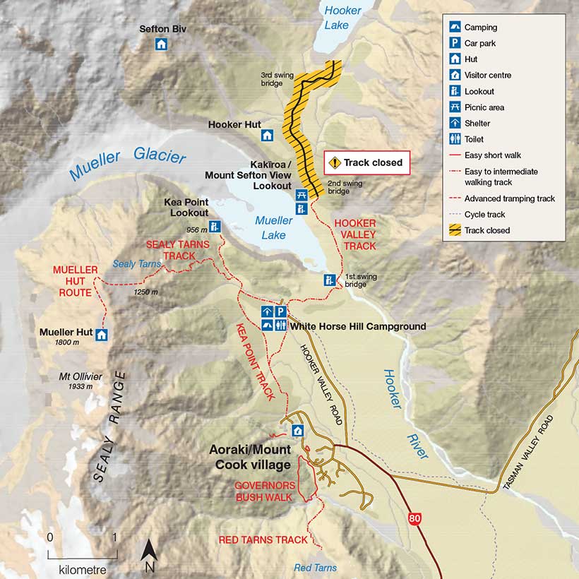
The track is closed beyond Kakīroa/Mount Sefton View Lookout while a new bridge is built. Flooding has eroded the riverbank under the existing bridge. The full track will reopen when the new bridge is built, likely in Autumn 2026.
See map showing track closure (JPG, 96K)
There are very limited views of Aoraki/Mount Cook from the open section of this track. You can view Aoraki/Mount Cook better from Kea Point Track (1-2 hours) or Sealy Tarns Track (3-4 hours, strenuous).
The track surface from White Horse Hill car park to Mueller Lake Lookout is a firm clay/gravel surface with easy grades. It is suitable for wheelchairs and buggies.
Beyond Mueller Lake Lookout there are several sections of steps which make wheelchair/buggy access difficult.
Car parking fees
Car parking fees apply at White Horse Hill.
How to pay fees or buy a permit.
The nearest towns are Aoraki/Mt Cook village (2 km), Tekapo (96 km) and Twizel (56 km).
The track starts at the White Horse Hill Campground and car park at the end of Hooker Valley Road.
The car park can be busy during peak times. We recommend visiting early in the day during summer and public holidays.
Weather
The Aoraki/Mount Cook region experiences very fast changes in weather. In this alpine environment it’s common to experience strong wind, high rainfall, heavy snowfall and rapid changes in temperature at any time of the year. Aoraki/Mount Cook National Park weather forecast – NIWA website.
Hooker Valley Track can become very icy in shaded areas and extremely slippery. We recommend microspikes and hiking poles for this track in winter.
Do not go in the water or on the ice
Stay out of the lakes in Aoraki/Mount Cook National Park. They are very cold (typically about 3 degrees celsius) and can quickly cause hypothermia.
Stay off the lakes when they are frozen over, as the ice can be thin and could give way at any time. Do not climb icebergs in the lakes as these are unstable and can tip unexpectedly.
You could put your life at risk by walking on the ice. If it gave way, you could drown or develop hypothermia.
Avalanche risk
The track is designed to avoid the risk of avalanche – keep to the tracks.
Amenities
- Wheelchair accessible toilets at White Horse Hill Campground at the start.
- A public shelter with tables/seating and potable (treated) drinking water at White Horse Hill Campground.
What to take
How to pack for a day walk
Car parking fees
The track to Mueller Hut starts near the White Horse Hill car park. DOC charges fees for car parking at White Horse Hill.
The fees are $2.50 per half hour or $25 a day. If you arrive and leave within 20 minutes, parking is free. If you plan to stay for longer than 20 minutes you must pay on arrival.
Payment machines that accept debit and credit cards are highly visible at each site. Cash payments are not accepted.
Locals and other car park users can purchase an annual permit. Permits cannot be purchased at the payment machines and need to be purchased online.
Note: If you arrive one day and leave the next you will pay car parking fees for two days ($50). If you plan to stay for multiple days ($50 or more) it may be more affordable for you to purchase an annual permit.
Many different wildflowers grow in this area, including celmisia and the Mount Cook buttercup/kōpukupuku, the world’s biggest buttercup.
Kea and kārearea (New Zealand falcon) can sometimes be heard and seen along the track.
Nature's in trouble
Thousands of New Zealand’s native species are heading towards extinction. Once they’re gone, they’re gone for good. Nature needs your help.
Aoraki/Mount Cook National Park Visitor Centre
| Phone: | +64 3 435 1186 |
| Email: | mtcookvc@doc.govt.nz |
| Address: | 1 Larch Grove Aoraki/Mount Cook 7999 |
| Hours: | Visitor centre hours and services |