Image gallery
Video
The marine reserve is about one and a half hours’ drive north of Auckland, near Leigh. Take SH1 to Warkworth and follow the Goat Island Marine Reserve signs.
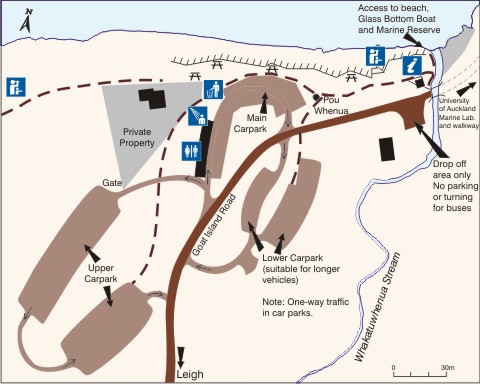
Map of facilities
Only swim/snorkel when conditions are calm and safe
People have died at this marine reserve. We do not recommend swimming, snorkelling or diving during the following conditions:
- east or north-east winds higher than 20 knots; and/or
- east or north-east swells of more than a metre.
It can be unsafe even when conditions are calmer. Be realistic about your skills and do not enter the water if you are unsure.
Check the wind speed and swell level on the Goat Island Surf Forecast. This is a surf forecast and the red/orange/green surfboard rating is not relevant to safe swimming, snorkelling or diving.
No dogs allowed
Dogs are not allowed in this area.
The marine reserve was the first to be established globally in 1975.
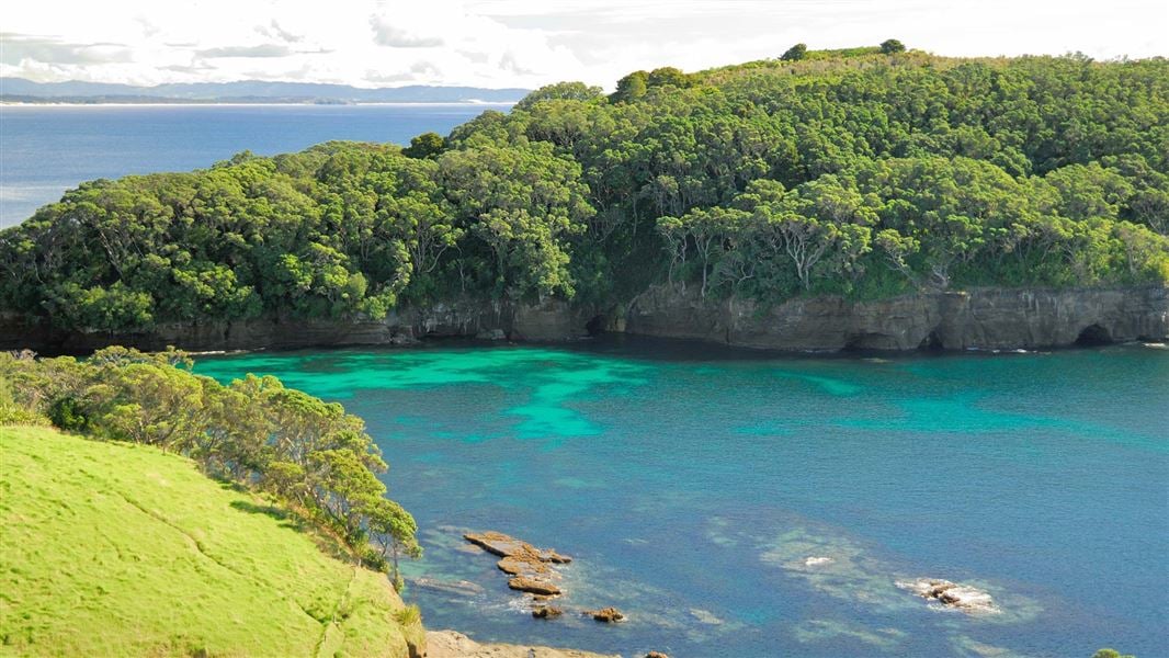
Extending from Cape Rodney to Okakari Point, the marine reserve includes the waters 800 m from shore including Te Hāwere-a-Maki/Goat Island.
The University of Auckland's Leigh Marine Laboratory is based next to the reserve. Its scientists make regular studies to discover how a marine ecosystem functions without harvesting or intervention. Be careful around any scientific equipment you may come across in the reserve.
Beneath the waves you may see seaweed forests, sponge gardens, and all the creatures of the rocky shore. The fish in the reserve are abundant and friendly.
Looking to stay dry when the weather is wet but still explore? The Goat Island Discovery Centre is a great place for the family to explore the ecosystem.
Find out how monitoring the marine reserve status has helped sea life in the area.
Help stop the spread of exotic caulerpa
Keep an eye out for exotic caulerpa seaweed species and report suspected sightings to MPI. Ensure your boat and gear are free of any seaweed before moving locations.
Reporting pest species
If you find something unusual that may be a pest:
- Record it: take photos and note the location and vessel name (if relevant).
- Identify it: upload your photo to iNaturalist for help from the online community.
- Report it: if you think it could be a new or harmful pest or disease, report it to the Ministry for Primary Industries (MPI) as soon as possible by calling 0800 80 99 66 or completing MPI’s online reporting form.
Report illegal or suspicious activity
Don't take, disturb, kill or damage anything within the reserve - it's illegal. If you see people taking anything from the reserve, report the activity as soon as possible.
You can call 0800 4 POACHER (0800 476 224) or 0800 DOCHOT (0800 362 468).
It is also an offence to pollute or litter the reserve, discharge any firearm in or into the reserve or erect any structure in the reserve.
Motu Hāwere is of central importance to the identity of Ngāti Manuhiri. The area is an iconic reminder of the early origins of Ngāti Manuhiri and their links with the earlier iwi of the area - Wakatūwhenua being the landing place of the Moekakara waka captained by Tahuhunuiarangi.
Motu Hāwere which shelters Wakatūwhenua, has the longer traditional name of Te Hāwere ā Maki. This sacred name is associated with Maki who led the conquest of the area in the late seventeenth century. Maki was the father of Manuhiri, the founding ancestor of Ngāti Manuhiri. The mana and mauri of this name and landmark, and the waters that surround it, is thus of immense significance to the iwi. The island was occupied as a pā by the Ngāti Manuhiri warrior ancestor Maeaea, who was a grandson of Manuhiri. It was on the basis of descent from Maeaea that Ngāti Manuhiri received title to Motu Hāwere in 1901.
The adjoining land was maintained as a kāinga and cultivation by Ngāti Manuhiri for many generations until after early European settlement. The land, known as the Wakatūwhenua Block, part of which forms the Leigh Recreation Reserve, was specifically reserved from sale to the Crown at the request of the Ngāti Manuhiri rangatira Te Kiri in 1861.
 No dogs allowed
To protect our native wildlife, dogs are not allowed anywhere in this place.
Protect our marine reserves
- No fishing of any kind.
- Don't take or kill marine life.
- Don't remove or disturb any marine life or materials.
- Don't feed fish - it disturbs their natural behaviour.
- Take care when anchoring to avoid damaging the sea floor.
DOC Customer Service Centre
| Phone: | 0800 275 362 |
| Email: | warkworth@doc.govt.nz |
| Address: | Mahurangi / Warkworth Office |