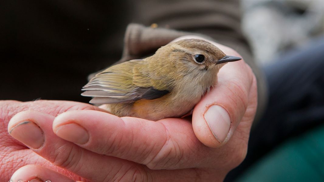
Our National Predator Control Programme protects native wildlife and forests at important conservation sites across New Zealand. Our goal is for healthy forests and thriving populations of unique native birds, bats, frogs, lizards and insects throughout New Zealand.
Currently, we control predators on a sustained, rotational basis over about 1.8 million ha which is nearly 20% of public conservation land.
It’s critical that rats, stoats, and possums are regularly controlled so that populations of threatened native species can survive and grow.
This is particularly important when beech forests produce more seeds than usual, known as a mast event. In summer 2026, native beech forests across the South Island had the largest beech mast in seven years. If we do nothing to control predators, abundant seeds can cause a surge in predator populations that devastate native wildlife.
DOC is leading an expanded predator control programme to protect native species. Most beech mast predator control operations happened before seeding in 2025 and will continue after seed is gone from late 2026. This two-round approach targets predators when food is scarce and they are most likely to eat bait.
Aerially applied 1080 is the best method available to control introduced predators and protect native species over large areas and rough terrain. We also use ground control tools, including traps and toxins in bait stations.
Protecting critical wildlife areas
We prioritise areas for predator control using the following criteria:
- the beech mast forecast and resulting increases in predator populations
- conservation planning with iwi, hapū and key community stakeholders
- risks to key ecosystems and populations of the most vulnerable species
- the history and results of previous predator control operations in the area.
The timing of operations is also determined by predator monitoring results and the weather.
The areas prioritised for 2026 are in the search tool below:
View all operations since 2022.
You can also view a summary map of all 2026 operations.
Check if tracks are safe for dogs
Following a predator control operation, it is not safe to hunt animals for food and walking tracks and forest areas are closed for dogs. These restrictions are in place for up to eight months.
For more information, see:
View a map
For more detailed information and operational boundaries:
Search for an operation
Search for information about this year’s operations using the filters or view the complete list of operations below. Descriptions of the operation status:
- Planned: DOC intends to carry out predator control in this location this year. Planning processes are underway, which include consultation, pest monitoring, obtaining DOC and Public Health Unit permissions
- Ongoing: for ground control operations this means traps and/or bait stations have been installed and are being actively managed
- Complete: the predator control operation has been carried out. Pesticides may still be present in the area – follow local warning signs and track alerts.
Northland
Puketi-Omahuta, Bay of Islands, Northland
Areas included or near by: Ōmahuta- Puketī Forest Conservation Park
Aerial or ground-based: Ground
Estimated hectares: 4979
Date: Winter 2026
Status: Planned
Species protected include:
Short-tailed and long-tailed bats, kiwi, NZ woodrose, Powelliphanta (kauri snails)
Waipoua, Kauri Coast, Northland
Areas included or near by: Waipoua Forest
Aerial or ground-based: Ground
Estimated hectares: 1790
Date: Winter 2026
Status: Planned
Species protected include:
Kokako, kiwi, Powelliphanta and long-tailed bats
Waikato
Whareorino, King Country, Waikato
Areas included or near by: Whareorino
Aerial or ground-based: Aerial
Estimated hectares: 4568
Date: Winter 2026
Status: Planned
Species protected include:
Archey's and Hochstetter's frogs and long-tailed bats
Mapara Ground, King Country, Waikato
Areas included or near by: Mapara Wildlife Management Reserve, Mapara Conservation Area
Aerial or ground-based: Ground
Estimated hectares: 1429
Date: Winter 2026
Status: Planned
Species protected include:
Kōkako, toutouwai/North Island robin, pekapeka/long tailed bats
Waipapa Ground, King Country, Waikato
Areas included or near by: Pureora Forest Park
Aerial or ground-based: Ground
Estimated hectares: 1174
Date: Winter 2026
Status: Planned
Species protected include:
NI kaka, kokako, NI robin, long-tailed and short-tailed bats
Taranaki
Parininihi, New Plymouth, Taranaki
Areas included or near by: Parininihi
Aerial or ground-based: Aerial
Estimated hectares: 5954
Date: Winter 2026
Status: Planned
Species protected include:
Kokako, kiwi, NI robin, Hall's totara
Pouiatoa - Taramakau, New Plymouth, Taranaki
Areas included or near by: Pouiatoa - Taramakau
Aerial or ground-based: Aerial
Estimated hectares: 6625
Date: Winter 2026
Status: Planned
Species protected include:
Black and hard beech, NI kiwi, kokako, NI robin
Bay of Plenty
Te Kopia, Rotorua, Bay of Plenty
Areas included or near by: Te Kopia Scenic Reserve
Aerial or ground-based: Aerial
Estimated hectares: 1561
Date: Winter 2026
Status: Planned
Species protected include:
Whio, short-tailed bats, red mistletoe and NZ woodrose
Rotoehu, Rotorua, Bay of Plenty
Areas included or near by: Rotoehu
Aerial or ground-based: Aerial
Estimated hectares: 2592
Date: Winter 2026
Status: Planned
Species protected include:
NI Kōkako, short-tailed and long-tailed bats, rifleman, NI Robin, NZ Falcon
Central North Island
Tongariro Kiwi Ground, Tongariro, Central North Island
Areas included or near by: Tongariro Conservation Area
Aerial or ground-based: Ground
Estimated hectares: 797
Date: Winter 2026
Status: Planned
Species protected include:
Whio, Western Brown kiwi
Rangataua Ground, Tongariro, Central North Island
Areas included or near by: Rangataua Conservation Area
Aerial or ground-based: Aerial
Estimated hectares: 6666
Date: Winter 2026
Status: Planned
Species protected include:
Short-tailed bats, Western Brown kiwi
Lower North Island
Northern Ruahine East, Manawatu, Lower North Island
Areas included or near by: Northern Ruahine Block 2
Aerial or ground-based: Aerial
Estimated hectares: 20171
Date: Summer 2026
Status: Completed
Species protected include:
Powelliphanta, long-tailed bats, kaka, whio and kiwi
Project Kaka, Wairarapa, Lower North Island
Areas included or near by: Tararua Forest Park
Aerial or ground-based: Aerial
Estimated hectares: 29800
Date: Summer 2026
Status: Planned
Species protected include:
Kaka, NZ falcon, North Island short-tailed bats, scarlet mistletoe, red mistletoe and tree fuchsia
West Coast
Kahurangi - Heaphy Lowlands, Buller, West Coast
Areas included or near by: Kahurangi National Park
Aerial or ground-based: Aerial
Estimated hectares: 27254
Date: Winter 2026
Status: Planned
Species protected include:
Powelliphanta, Long-tailed bats
Kahurangi - Garibaldi-Kakapo, Buller, West Coast
Areas included or near by: Kahurangi National Park
Aerial or ground-based: Aerial
Estimated hectares: 47177
Date: Summer 2026
Status: Completed
Species protected include:
Rock wren, whio, Great spotted kiwi, kea, kaka, long-tailed bats and Powelliphanta
Kahurangi - Parapara, Buller, West Coast
Areas included or near by: Kahurangi National Park
Aerial or ground-based: Aerial
Estimated hectares: 33901
Date: Winter 2026
Status: Planned
Species protected include:
Powelliphanta, pitpat (Pittosporum patulum)
Kahurangi - New Creek, Buller, West Coast
Areas included or near by: Kahurangi National Park
Aerial or ground-based: Aerial
Estimated hectares: 66725
Date: Spring 2026
Status: Planned
Species protected include:
Kea, long-tailed bats, whio, kaka, kakariki, Great spotted kiwi and mistletoe
Kahurangi - Cobb, Golden Bay, West Coast
Areas included or near by: Kahurangi National Park
Aerial or ground-based: Aerial
Estimated hectares: 71560
Date: Winter 2026
Status: Planned
Species protected include:
Kea, Powelliphanta, mistletoe, pitpat (Pittosporum patulum)
Te Maruia, South Westland, West Coast
Areas included or near by:
Aerial or ground-based: Aerial
Estimated hectares: 37217
Date: Winter 2026
Status: Planned
Species protected include:
Kaka, Long-tailed bats, rock wren, mistletoes
Arawhata, South Westland, West Coast
Areas included or near by: Arawhata Conservation Area, Mount Aspiring National Park
Aerial or ground-based: Aerial
Estimated hectares: 76309
Date: Summer 2026
Status: Completed
Species protected include:
Haast tokoeka kiwi, South Island kākā, tuke/rock wren, and the Cascades forest gecko
Haast kiwi, South Westland, West Coast
Areas included or near by: Haast kiwi sanctuary
Aerial or ground-based: Ground
Estimated hectares: 11158
Date: Winter 2026
Status: Planned
Species protected include:
Haast tokoeka/kiwi, pekapeka/bats, kākā
Canterbury
Wilberforce, Canterbury, North Canterbury
Areas included or near by: Wilberforce-Mathias
Aerial or ground-based: Aerial
Estimated hectares: 23769
Date: Spring 2026
Status: Planned
Species protected include:
Kea, SI kaka, Hall's totara, Mountain cedar, kakariki, rock wren, whio and long-tailed cuckoo
Arthur's Pass, Canterbury, North Canterbury
Areas included or near by: Arthur's Pass East
Aerial or ground-based: Ground
Estimated hectares: 10000
Date: Winter 2026
Status: Planned
Species protected include:
Great spotted kiwi, mohua, rock wren, kea, whio, SI kaka, orange fronted kakariki, yellow crowned parakeet and mistletoe
Fiordland
Murchison Mountains, Te Anau, Fiordland
Areas included or near by: Fiordland National Park, bounded by Lake Te Anau
Aerial or ground-based: Ground
Estimated hectares: 27013
Date: Winter 2026
Status: Planned
Species protected include:
Takahe, kea, whio, kiwi, rock wren and short-tailed and long-tailed bats.
Otago
Dart River, Wakatipu, Otago
Areas included or near by: Dart River Ground
Aerial or ground-based: Ground
Estimated hectares: 706
Date: Winter 2026
Status: Planned
Species protected include:
Mohua, pekapeka/long-tailed bat, kea, yellow crowned parakeet/kākāriki, whio, rock wren and falcon
Makarora, Central Otago, Otago
Areas included or near by: Mount Aspiring National Park
Aerial or ground-based: Aerial
Estimated hectares: 33500
Date: Summer 2026
Status: Completed
Species protected include:
Mohua, whio, kaka, kea, rock wren, and long-tailed bats
Southland
Blue Mountains, Invercargill, Southland
Areas included or near by: Blue Mountains Forest Conservation Area
Aerial or ground-based: Aerial
Estimated hectares: 11964
Date: Winter 2026
Status: Planned
Species protected include:
Mohua