Two sea currents converge at Kapiti and race through the Rauoterangi Channel, which separates Kapiti Island from New Zealand’s North Island. The cold, clear Southland current moves north, opposing the warmer, cloudier and saltier waters of the d’Urville current.
The wind and swells favour one current over the other at different times. This creates a zone that supports a fascinating mix of marine plant and animal communities, which would usually be found in colder or warmer waters. For example, cooler-water fish like blue moki and kingfish are found here as well as subtropical species such as spotted black grouper and blue maomao that are more common further north.
A marine reserve in two parts
Inner
The inner, eastern part of the marine reserve (between Kapiti Island and the mainland) is relatively sheltered, with silt, gravel and sand on the seafloor. It is an important breeding area for fish, scallops, crabs, pāua and rock lobster (crayfish/koura).
Reaching 70 m at its deepest point, the area includes sponge gardens and large anemone beds. Small, delicate, hard red seaweeds (coralline algae and rhodoliths) are found here as well as larger seaweeds and kelp.
The Waikanae River flows down from the Tararua Ranges and reaches the coast at the marine reserve. Fresh and salt water mix here, creating an environment where plant and animal communities can thrive. Native fish, waders and sea birds flourish in the estuary environment.
Outer
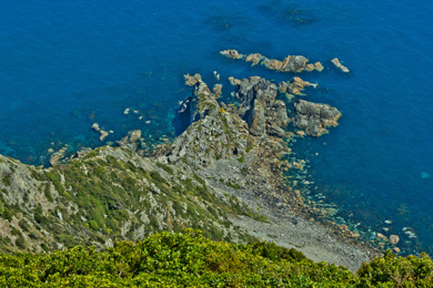
Kapiti cliff side
Image: Brandon Skilton | Creative Commons
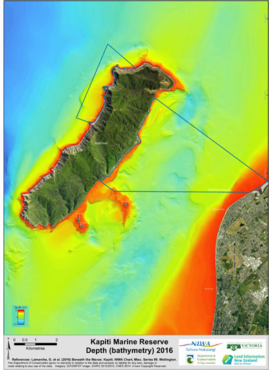
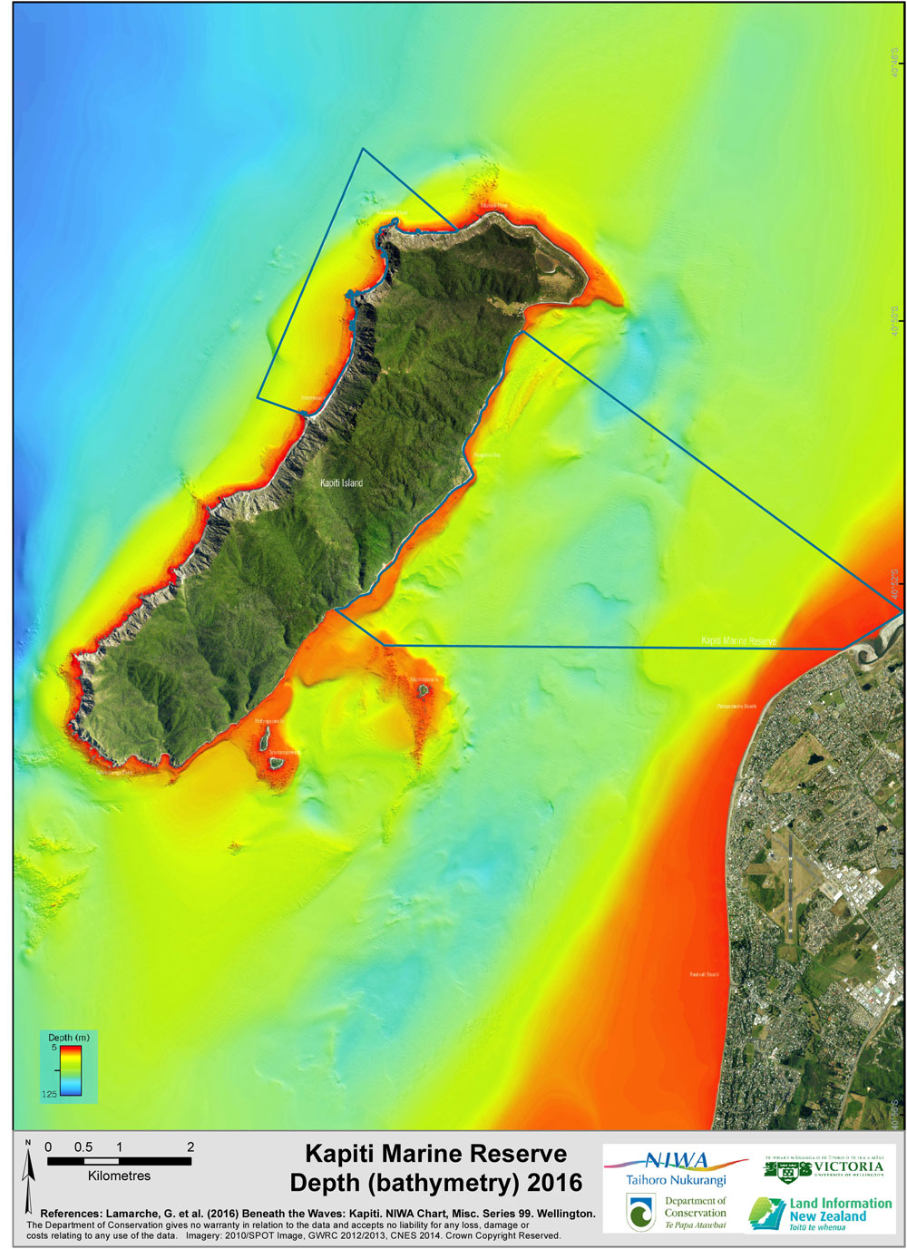
Kapiti Marine Reserve depth, 2016 View larger (JPG, 276K)
Image: DOC, NIWA, VUW, LINZ
By contrast, the outer part of the marine reserve is rocky, exposed and covered with forests of large brown kelp. The seafloor is bouldery, the water is clear and the kelp forests create habitats for many other seaweeds and marine animals. Butterfish (greenbone), perch, pāua and red moki are found here.
Status: good
The habitat diversity was assessed by comparing the area’s actual diversity with its expected diversity. The expected habitats are found in the marine reserve and are typical of the Kapiti coast.
Trend: undetermined
Subtidal habitat was recorded at 11 sites during the baseline study in 1992 and again in the 2014 survey. Habitat was also surveyed at 6 of the monitoring sites in 2000 and a seabed habitat map was created in 2016.
Baseline survey
A survey around Kapiti Island in 1992 (the year the marine reserve was created) identified the habitat and the quantities and size of fish, pāua, rock lobster and other species at 11 sites close to shore. Three survey sites were in the outer part of the marine reserve, three sites in the inner part of the marine reserve and the remaining sites were outside the marine reserve.
The survey is a valuable record from which to track changes in the marine environment. The survey was repeated at the same sites in 2014 and shows how the habitat and mix of species has changed since the formation of the marine reserve.
Kapiti seabed mapping
This map of the area around Kapiti Island displays the shape and depth of the sea floor. It was created using a multibeam echosounder, which records the reflection of sound waves bounced onto the sea bed. The technique builds a detailed picture of the sand waves, rocky reefs and sediment flats on the seabed as well as its mineral content. This provides valuable information about the currents and undersea erosion, and past geological events that raised Kapiti Island above the sea.
The project used drop camera and diver surveys as well as video transects at specific sites to confirm the multibeam results. This work was carried out by a team of marine scientists from NIWA, LINZ, Victoria University of Wellington and DOC. The multibeam project also received support from Greater Wellington Regional Council, Ngāti Toa Rangatira and the Kapiti Coast community.
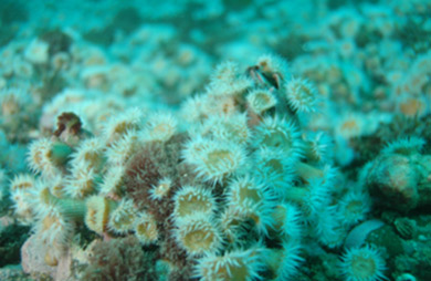
White-striped anemone bed
Image: Vincent Zintzen ©
Watch a video about how this map was created.
The scientists found fields of white-striped anemones (Anthothoe albocincta) that extended for hundreds of metres. Although the anemone is common in New Zealand, its occurrence in such large areas blanketing the sea floor is very unusual.
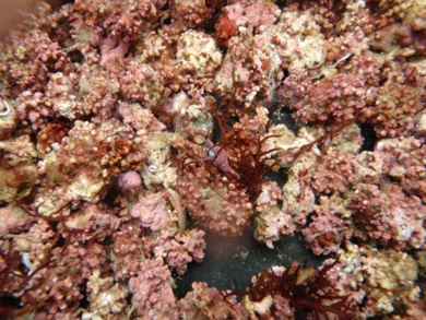
Rhodoliths – image taken from underwater video
Image: DOC
Rhodoliths
Large beds of rhodoliths (a rare type of hard red seaweed) are found at the southern end of the marine reserve. Like coral, rhodoliths are fragile, made of calcium carbonate and grow very slowly, only 0.05–2 mm per year. Unlike coral, which is an animal, rhodoliths are plants and are not attached to the sea floor.
Rhodoliths provide a three-dimensional structure on the sea floor that enable new marine communities to form. The spaces between a rhodolith’s long lumpy ‘arms’ are an ideal place for young crabs and fish to grow up, safe from their predators.
Rhodoliths are only known from a few places around New Zealand. They are sensitive to changes in water quality and to human activities that disturb the seabed, such as trawling, dredging and anchoring. Their presence in the marine reserve is an indicator of good ecosystem health.
Reports
- Sensitive marine benthic habitats defined. NIWA 2013. Prepared for the Ministry for the Environment.
- Quantitative description of mainland New Zealand’s shallow subtidal reef communities. (PDF, 3,100K) Shears and Babcock 2007.
- From our Marine survey reports download folder:
- A survey of the marine habitats and communities of Kapiti Island (PDF, 18,110K) Battershill et al. 1993. Note: this is a very large file.