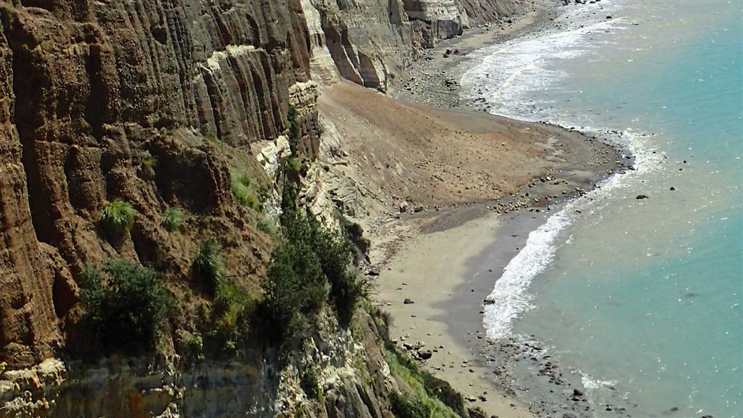
The journey from Clifton along the beach to see the nesting gannets at Cape Kidnappers involves a number of hazards that people need to be aware of – unstable cliffs, periodic landslide and rockfall, and it can only be attempted safely at low tide.
A report of the geological hazards from the cliffs has shown the risk from potential landslides and rockfalls for people travelling along the beach is equivalent to that faced by people undertaking mountain climbing. The risk levels due to the landslide risk are high and there is a real chance of serious injury or fatality, much higher than a walk along a typical beach.
How have we assessed the risks?
Hastings District Council and DOC are jointly managing the risks to visitors at this place.
One of the main tools we have used to understand the risks associated with the cliffs is a Quantitative Risk Assessment (sometimes called a QRA). These are undertaken by specialists using a systematic approach to identify the risks, assess which need treatment and what the priorities are. We also provide information about the risks to visitors to support them to make decisions about whether it’s a level of risk they’re willing to accept.
This sort of risk assessment is an evolving field of science and psychology. Decisions made today or tomorrow to manage visitors may be different to decisions that were made in the past.
Who is responsible for managing risks?
DOC and the council have a responsibility to alert people to the significant hazards and risks they may encounter on their trip. We also advise on their options for minimising that risk. This allows visitors to make up their own minds about proceeding.
In some circumstances the risk is so great that a managing authority will block off or prohibit access.
Commercial tourism operators also have a responsibility to their clients to ensure they understand the risks associated with the activity they are providing. DOC is responsible for considering the safety of any commercial operation it has issued a concession for – for the operator, their employees and their clients.
Understanding the risks associated with tourism on public conservation lands and waters requires input from experts in the area of risk that needs to be managed for. It is also managed within relevant legislation and regulations.
Quantitative Risk Assessment
The final Quantitative Risk Assessment (QRA) provides a profile on the level of risk from geological hazards (landslides and rockfalls) to people using the beach and the track to the gannet colony. This is supported by a Hazard Assessment Report, which has been used as a reference for understanding and calculating the level of risk associated with the geological hazards on the beach. Both these documents are below.
The QRA states that although the risk levels are similar to some other active landscape areas in New Zealand, they are high compared to the level and type of risk that people would expect to face on an everyday leisure activity.
The QRA identifies the overall risk of serious harm or fatality resulting from landslide or rockfall while travelling along the beach is far higher than had previously been assumed. The highest risk area is along the beach.
Recommendations from the QRA outline what could be done to lower the risk, monitor the risk and lead to better informed risk.
DOC seeks, wherever possible, to provide people with unrestricted access to conservation lands. While we can never eliminate all risk in a natural environment, we can set expectations and provide people with better information to help them understand these risks and make informed choices about where they go.
We have updated our management approach to reflect the level of risk. Our website information and the signage at the entrance to the beach have been updated. As this trip is more similar in risk profile to those at a remote site, the DOC track will in future be managed at a tramping standard, which also matches the beach access which has no formed track.
By aligning our management approach with those of a remote site, including the facilities and information we provide, we aim to discourage people who are simply after a casual walk along the beach.
Summary of risks identified by the QRA
GNS have identified the risk as equivalent to that of people undertaking a mountain experience (excluding Aoraki/Mt Cook itself which has a higher risk profile). The risk of travelling along the beach is compared to walking the Tongariro Crossing or climbing Mount Snowden, a mountain in the United Kingdom.
For independent walkers the risk is mostly associated with the Hastings District Council (HDC)-managed area of beach (86%), while the risk associated with the DOC-managed beach is 12%. The remaining 2% is associated with the DOC track from the beach to the plateau gannet colony.
For locals using the beach for regular recreational purposes, the level of risk is based on a local person accessing the beach a set number of days per year. The risk will be greater the more frequently someone travels along the beach – the more often someone walks, the higher their chances of being hit by a landslide or rockfall. This is a relatively high-risk activity.
For clients of the beach transport operation the risk is lower than someone travelling by foot, but is still extremely high and comparable to the risk of doing activities like mountaineering, rafting or tramping in remote and rough terrain.
For employees of the beach transport operation there are very high risk levels, at least equivalent to workers in the forestry industry.
For DOC staff having to cross the beach to carry out work, the risk is within a range that would be considered substantial but tolerable. Risk to workers could be reduced to a very low level by minimising or eliminating time on the beach.
There is a significant societal risk, which is if a large group of people or people that society deem vulnerable (such as children) get killed in one incident. The societal risk is highest on the beach transport operation, as it has sizeable groups exposed to the risk. While each walker has a higher individual risk than each tractor trip passenger, it is less likely there would be a big multiple-fatality event with walkers as people do not tend to walk in large groups. Societal risk will only reduce if there are less visitors exposed to the hazard.
The QRA does not include an analysis of other hazards at the site, such as tsunami, being caught by the incoming tide or debris flows from flooding of gullies in the farmland above. This means the total risk to a visitor would be higher than the QRA report identifies. The risk of being caught by the tide is already managed through making people aware they need to time their trip to avoid being caught by the tide.
More information
- Cape Kidnappers visitor experience management plan (PDF, 5,875K)
- GNS quantitative risk assessment report (PDF, 12,230K)
- Stantec hazard assessment report (PDF, 25,099K)
- Cape Kidnappers recommendation paper (PDF, 211K)
- Cape Kidnappers options paper (PDF, 713K)
- DOC incident investigation report - Cape Kidnappers rockfall (PDF, 13,973K)
- Gannet Beach Adventures submission on the Cape Kidnappers 2019 rockfall incident investigation report (PDF, 261K)