Holdsworth - Kaitoke Track
Located in Holdsworth area and Tararua Forest Park in the Wairarapa region
|
Introduction
This is one of the classic tramps of the Tararua Forest Park. It follows the Waiohine and Tauherenikau rivers between Holdsworth and Kaitoke.36 km one way
Dog access
Day one: Holdsworth – Totara Flats Hut: 4 hr
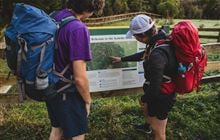
The track begins at the Holdsworth car park at the end of Holdsworth Road. There is a campsite and bookable lodge near the road.
From Holdsworth Lodge, cross the bridge and continue up the track in the direction of Donnelly’s Flat. Turn left at the signpost onto the track to Powell Hut and climb the Gentle Annie track towards Mountain House Shelter. This track is a well graded, well formed walkway, and offers several lookout points.
Follow this track until the turnoff to Totara Flats Hut. From the turnoff onwards, the track is less well-formed, muddy in places, steep with many tree roots.
Follow the Totara Creek Track along the ridge to a high point, 575 m, and continue along the track, heading down towards Totara Creek. Follow the creek on the true left to the swing bridge crossing, then continue downstream on the true right.
At the Waiohine River, cross the bridge and turn left to Totara Flats Hut.
Totara Flats has numerous camping sites. Campers who use hut facilities are required to pay one hut ticket.

Day two: Totara Flats Hut – Tutuwai Hut: 6 hr
From Totara Flats Hut, the track continues down the Waiohine River river and across Totara flats. Before reaching a high bluff, the track swings away from the river. It climbs steeply up onto a high river terrace and then continues downstream.
The track soon reaches a large slip. There are two options for how to pass the slip. Either follow the all-weather track over the slip (30 minutes), or walk downstream on the river terrace to Makaka Creek. The second option is only possible when the river is low; if in doubt, take the all-weather track.
Cross the Makaka Creek bridge and climb up the bank to the marked junction. This is where the Cone Saddle Track separates from the Lower Waiohine Track.
Turn right onto the Cone Saddle Track at the junction and climb steadily up a spur to the ridge top. From here the track sidles into Clem Creek and climbs to Cone Saddle. Descend the track to Cone Hut in the Tauherenikau Valley.
Expect to encounter stream crossings, muddy sections and fallen trees on the Cone Saddle Track. The track can be narrow and indistinct in places, so keep a close eye on the orange markers.
Allow plenty of time for this section.

From Cone Hut follow the track down the Tauherenikau river valley. The track passes through muddy terraces and grassy flats. There are regular crossings of small side streams. Tutuwai Hut is about 1.5walk from Cone Hut.
There are grassy areas near Tutuwai Hut that are good camping sites. Campers who use hut facilities are required to pay one hut ticket

Day three: Tutuwai Hut – Kaitoke Roadend: 5 hr
From Tutuwai Hut continue on the track down the true left of the Tauherenikau Rover, crossing grass flats and bush terraces and passing low wide slips. Slips and washouts along this section of the track have caused the terrain in some areas to become steep, narrow and slippery – the slips can be difficult to negotiate. Caution is required.
The track then crosses the Tauherenikau River on a swingbridge. Continue following the track downstream. It crosses several unbridged side streams. Take care and cross with caution, especially if the stream levels are up or if it is raining.
After crossing grassy river flats, Smith Creek shelter is reached. The shelter is not suitable for overnight stays.
The track from here follows Smith Creek upstream along the Dobson Loop Track, crossing more unbridged side streams. Beyond Smith Creek, expect to encounter small slips, stream crossings, muddy and slippery sections and windfalls across the track.
The track becomes Puffer Track and leaves Smith Creek. It climbs to Puffer Saddle and down to the Kaitoke road end carpark, located along Kiwi Ranch Road.
Holdsworth
Turn off State Highway 2 onto Norfolk Road, 2 km south of Masterton. This is signposted and there is a timber processing plant on the corner. Follow Norfolk Road 15 km to Holdsworth road end.
Kaitoke
Turn off State Highway 2 onto Marchant Road (signposted at the western side of the Remutaka Hill) at the YMCA Camp Kaitoke turnoff. Near the end of Marchant Road, turn right into Kiwi Ranch Road. The carpark is located on the left, approximately 500 m along Kiwi Ranch Road.
Expect a rough, backcountry track
The Holdsworth-Kaitoke track is a backcountry tramping experience. The track is rough and uneven. Walkers need to be ready to climb around slips and over fallen trees. The track is indistinct in places so walkers need to be confident navigating and following markers.
This track is best for people who have some experience in backcountry tramping.
Leave extra time
Slips, fallen trees or bad weather can make this track take longer than expected. Plan your days with extra time.
Be ready for rain and cold, pack for emergencies
The Tararua Forest Park is well-known for changeable and wild weather. Check the forecast before you go and pack plenty of warm and waterproof clothes. Pack extra food in case you are delayed by weather.
There is no cell phone reception on most of this track, so carry a distress beacon.
It is advisable to carry emergency shelter to be prepared for an unexpected night out.
Stay safe when crossing rivers
If you plan to cross unbridged rivers, know how to cross safely and be prepared for if you cannot cross.
Do not cross if the river is flooded, you cannot find safe entry and exit points or are unsure it’s safe. Turn back or wait for the river to drop. If in doubt, stay out.
Stay safe in the outdoors
- Choose the right trip for you. Learn about the route and make sure you have the skills for it.
- Understand the weather. Check weather forecasts.
- Pack warm clothes and extra food. Check gear lists.
- Share your plans and take ways to get help. Share directly or use the Outdoor Intentions form or Plan My Walk. Take a distress beacon.
- Take care of yourself and each other.
Contacts
| Wellington/Kapiti information | |
| Phone: | +64 3 546 9339 |
| Email: | nelsonvc@doc.govt.nz |
| About: | Whakatū/Nelson Visitor Centre provides visitor information for this area |