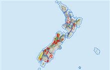
North Opuha Conservation Area hunting
Located in Mid & South Canterbury hunting in the Canterbury region
|
Introduction
North Opuha Conservation Area is about 31 km north of Fairlie. Tahr, chamois, red and fallow deer and the occasional wallaby are present.Species
- Chamois
- Deer - Fallow
- Deer - Red
- Tahr
- Wallabies
Permit requirements
This hunting area is covered by an 'open area permit' – get it online or from a DOC office.
Dog access
About this hunting block
General information
The North Opuha Conservation Area is part of the Te Kahui Kaupeka Conservation Park and covers an area of about 1,797 hectares.
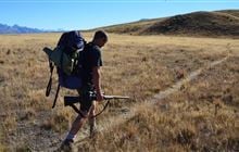
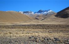
The terrain is steep and mountainous on the southern end of the Ben McLeod Range with the highest point being 2000 m. The lower steeper slopes and gullies contain mixed shrublands, while the higher slopes are broad sweeps of red and narrow-leaved snow tussock grasslands. Significant wetlands dominated by red tussock are found on the valley floor.
Access
Turn off SH79 (Geraldine-Fairlie Highway) onto Clayton Road 1 km outside Fairlie. After crossing the North Opuha bridge (21 km), turn left down Fox Peak Ski Field Road. There is a DOC car park just before the end of the road.
From the car park, walk up the road, then along the true left bank of the North Opuha River. After leaving the river a marked easement across freehold land (no hunting on easement) gives access to the upper North Opuha Conservation Area.
Helicopter landings may be approved provided an appropriate landing permit is obtained.
Topo map
NZTopo50 map sheet: BY18 Ashwick Flat
Dogs
Dogs are permitted.
Huts
Additional information
Check for current pesticide operations that may be in progress where you intend to hunt.
Contacts
| Raukapuka / Geraldine Office | |
| Phone: | 0800 275 362 |
| Email: | info@doc.govt.nz |
| Address: |
13 – 15 North Terrace Geraldine 7930 |
| Postal Address: |
PO Box 33 Geraldine 7956 |
| Full office details | |