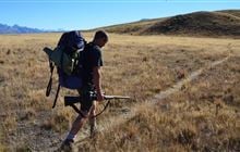
Two Thumb hunting
Located in Mackenzie Country & Waitaki hunting in the Canterbury region
|
Introduction
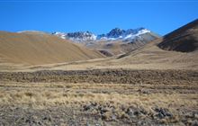
This region covers the range east of Lake Tekapo and south of Two Thumb Stream. The area carries tahr and chamois.Species
- Chamois
- Deer - Red
- Tahr
Permit requirements
This hunting area is covered by an 'open area permit' – get it online or from a DOC office.
Dog access
About this hunting block
General information
This region covers the range east of Lake Tekapo and south of Two Thumb Stream. It is part of Te Kahui Kaupeka Conservation Park. The area carries tahr and chamois.
Access
Access to the northern end of the Two Thumb Range is through public conservation land in the Macaulay Valley via North East Gorge Stream and Two Thumb Stream.
Access to the middle of the Two Thumb Range is via a courtesy track at the boundary between Mt Gerald Station and Richmond Station (north of Coal River). This is not a legal route but a track for the public to use at the goodwill of the landowners.
Another access alternative is via the Roundhill Snow Area Road. Permission is required from Richmond Station as this not a public road.
Landholders
- Michael Burtscher, Mt Gerald Station
- Oskar and Karoline Rieder, Richmond Station
Maps
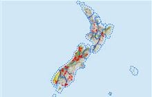
- Topo50 BY17, BY18, BX17.
- Two Thumb hunting area map (PDF, 498K)
Huts
Know before you go
Dogs
Open area except for in the Roundhill Snow Area, where dogs are only allowed by permit for snowfield management purposes.
Contacts
| DOC Customer Service Centre | |
|---|---|
| Phone | 0800 275 362 |
| info@doc.govt.nz | |
| Address | DOC offices |