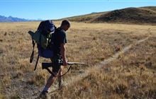
Hall Range hunting
Located in Mackenzie Country & Waitaki hunting in the Canterbury region
|
Introduction
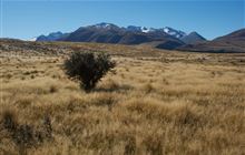
This range sits between the Godley and Cass rivers northwest of Lake Tekapo and incorporates the western side of the Hall Range and all of Haszard Ridge. Tahr and chamois are found here.Species
- Chamois
- Tahr
Permit requirements
This hunting area is covered by an 'open area permit' – get it online or from a DOC office.
Dog access
About this hunting block
General information
This range sits between the Godley and Cass rivers northwest of Lake Tekapo and incorporates the western side of the Hall Range and all of Haszard Ridge. Tahr and chamois are found here.
Access
It is possible to walk up the Cass River from the Cass River Bridge on the Godley Peaks Road; permission is not required for this option.
For walking access to Mistake Creek, permission is required from Godley Peaks Station.
Helicopters can fly directly to Middle Gorge Hut, Mistake Creek. Check that the helicopter operator has the relevant permissions and concessions to land in this area.
Landholders
Rob and Helen Glover, Godley Peaks Station
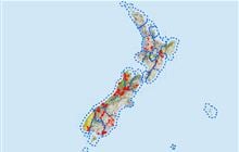
Maps
- Topo50 BY16, BX16
- Hall Range hunting area map (PDF, 493K)
Huts
Know before you go
Dogs
Dogs are only allowed in this area with permission from the landholders, and must be under control. Dogs should be kept on a lead at all times in riverbed areas and wetlands between the months of August and the end of February, because of nesting birdlife.
Help control wallabies in this area by reporting sightings
Wallabies can displace other species, affect pastures and native species' habitats.
They also potentially impact production and native ecosystems.
Report your sighting online – it only takes a few minutes.
You can also report wallaby sightings by calling 0800 80 99 66.
Contacts
| Te Manahuna / Twizel Office | |
| Phone: | 0800 275 362 |
| Fax: | +64 4 471 1117 |
| Email: | info@doc.govt.nz |
| Address: |
15 Wairepo Road Twizel 7901 |
| Postal Address: |
Private Bag 951 Twizel 7944 |
| Full office details | |