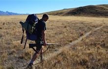
Sugarloaf hunting
Located in Mount Aspiring National Park east of the Divide hunting in the Otago region
|
Introduction
You can hunt chamois, whitetail and red deer in the Sugarloaf hunting block.Species
- Chamois
- Deer - Red
- Deer - White-tail
Permit requirements
This hunting area is covered by an 'open area permit' – get it online or from a DOC office.
Seasonal restrictions
Before lighting a fire on public conservation land, check it's alright to light. Extinguish all fires before leaving huts and campsites. How to minimise the risk of fire.
Dog access
About this hunting block
Animals present are chamois, whitetail and red deer.
General information
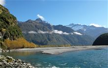
This block takes in the true left flanks (only once 500 m away from the Routeburn Track) of the lower Routeburn Valley including Bridal Veil Falls, Sugarloaf Stream and Sugarloaf itself.
Hunting is not permitted:
- within 500 m of the Routeburn Track, and rifle bolts must be removed while in the Routeburn Valley, and
- in the area bordered by the Dart River, the Route Burn and Lake Sylvan due to it being a high use tramping area.
Access
Access is by following the Routeburn Track for 15 minutes before turning up Sugarloaf Stream – the hunting block begins once 500 m away from the Routeburn Track.
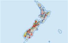
Maps
NZTopo50 series: CB09
Sugarloaf hunting block map (PDF, 778K)
Dogs
Dogs are not allowed in this block as it is part of Mount Aspiring National Park.
Contacts
| Whakatipu-wai-Māori / Queenstown Office | |
| Phone: | 0800 275 362 |
| Fax: | +64 4 471 1117 |
| Email: | queenstown@doc.govt.nz |
| Address: |
Cavells Building 1 Arthurs Point Road Queenstown 9371 |
| Postal Address: |
PO Box 811 Queenstown 9348 |
| Full office details | |