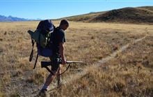
Lower Dart hunting
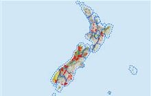
Located in Mount Aspiring National Park east of the Divide hunting in the Otago region
|
Introduction
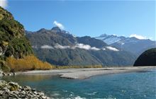
This block includes both sides of the Dart Valley between Daleys Flat and Sandy Bluff and offers opportunities to hunt goats, chamois, whitetail and red deer.Species
- Chamois
- Deer - Red
- Deer - White-tail
- Goats
Permit requirements
This hunting area is covered by an 'open area permit' – get it online or from a DOC office.
Seasonal restrictions
Before lighting a fire on public conservation land, check it's alright to light. Extinguish all fires before leaving huts and campsites. How to minimise the risk of fire.
Dog access
About this hunting block
Animals present are goats, chamois, whitetail and red deer.
General information
This block includes both sides of the Dart Valley between Daleys Flat and Sandy Bluff. The terrain is large terraced flats, pleasant beech/tawhai forest and higher up, steeper slopes tussock, rock and snow.
Below Sandy Bluff on the true left, the block continues down as far as Chinamans Bluff. Hunting is not allowed further down as this is part of the Dart Moratorium Area, imposed over forests in the lower Dart Valley/Earnslaw Burn in 1983 for the management of whitetail deer.
On the true right, hunting is prohibited between McBride Burn and the Beans Burn catchment – this is Te Korokā (Dart/Slip Stream) Specially Protected Area, entry by special permit only.
Hunting is also prohibited within 500 m of the Dart Valley Track.
Access
Use the Dart Track which begins at Chinamans Bluff, 76 km from Queenstown via Glenorchy.
Maps
- NZTopo50 series: CA10
- Lower Dart hunting block map (PDF, 770K)
Dogs
Dogs are not allowed in this block as it is part of Mount Aspiring National Park.
Huts
Contacts
| Whakatipu-wai-Māori / Queenstown Office | |
| Phone: | 0800 275 362 |
| Fax: | +64 4 471 1117 |
| Email: | queenstown@doc.govt.nz |
| Address: |
Cavells Building 1 Arthurs Point Road Queenstown 9371 |
| Postal Address: |
PO Box 811 Queenstown 9348 |
| Full office details | |