Red Hills - Mt Richmond Forest Park
Located in Nelson Lakes hunting in the Nelson/Tasman region
|
Introduction
The Red Hills has low to moderate red deer numbers. Goats can also be encountered throughout the area and the odd pig may show up in the forested area but their numbers are generally low.Species
- Deer - Red
- Goats
- Pigs
Permit requirements
This hunting area is covered by an 'open area permit' – get it online or from a DOC office.
Dog access
About this hunting block
General information
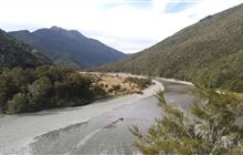
Situated at the south western edge of the Mt Richmond Forest Park, the Red Hills are a unique ultramafic geological area composed of very dense magnesium-rich rocks which have been thrust up at least 10 km or more from below the earths crust. The soils derived from these magnesium-rich rocks are too toxic for tree growth so much of the area is covered in distinctive scrub and tussock. This ultramafic area runs from Ben Nevis in the north approximately 20 km south to State Highway 63.
The Red Hills has low to moderate red deer numbers which tend to stay within the forested areas more than the ultramafic.
Goats can also be encountered throughout the area and the support of recreational hunters in controlling these animals in this fragile environment would be much appreciated.
The odd pig may show up in the forested area but their numbers are generally low.
Access
The Te Araroa Trail enters the top of the Red Hills at Top Wairoa Hut through to the Red Hills Hut just north of State Highway 63. Access to the Red Hills Hut is by walking track from a car park off State Highway 63 at the Six Mile Reserve, there is now no road access.
Direct access to Hunters Hut can be gained by driving up to Inwoods Lookout from the forestry access road at the bottom of the Nelson side of Reay Saddle then walking over Gordons Knob and down to the hut, or following the track up the Motueka River from the Blue Glen roadend.
The Top Wairoa Hut can be accessed from the north via the West Branch Wairoa Road and the Mid Wairoa Hut.
Landholders
There is a public easement through the Golden Downs and Wairoa forests to Inwoods Lookout, Blue Glen roadend, left branch Wairoa Road, Boundary Road and Cedar Road.
Map information
NZTopo50 BR25
Dogs
Hunting dogs are allowed by permit only and are allowed to be overnight in the area.
Dog permits are available from the local DOC office.
Hut information
Additional information
The type of rock encountered in the Red Hills is very sharp and hard so is very abrasive to boots or the human body. Care should be taken when moving through this type of strata.
Summer heat reflecting off the rocks can also be quite intense so ample water should be carried.
About Teetotal sighting-in range
Teetotal sighting-in range is located off Teetotal Road in the Teetotal Recreation Area approximately 3.3km northwest of St. Arnaud.
Hunters can safely check their rifle sightings at the Teetotal sighting-in range facility before heading into nearby parks and conservation land to hunt.
To use the sighting-in range you must have a Teetotal sighting-in range permit, or be under the supervision of a Range Officer. This is a legal requirement under the Arms Act 1983 from 1 July 2023.
Contacts
| Rotoiti / Nelson Lakes Visitor Centre | |
| Phone: | +64 3 521 1806 |
| Email: | nelsonlakesvc@doc.govt.nz |
| Address: |
View Road St Arnaud |
| Postal Address: |
PO Box 55 St Arnaud 7053 |
| Full office details | |


