Mount Harper/Mahaanui hunting
Located in Mid & South Canterbury hunting in the Canterbury region
|
Introduction
Mt Haper/Mahaanui is open all season. Red deer, chamois are present in low numbers and also the occasional tahr and pig.Species
- Chamois
- Deer - Red
- Pigs
- Tahr
Permit requirements
This hunting area is covered by an 'open area permit' – get it online or from a DOC office.
Dog access
About this hunting block
General information
Mt Harper/Mahaanui is on the true left of the Rangitata River, 28 km northwest of Mt Somers township. It is part of the Hakatere Conservation Park.
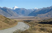
The area is about 6,076 hectares and is centred around Mt Harper/Mahaanui (1829 m). The vegetation is mainly tussock and alpine herbfields with some matagouri in gullies and at lower levels.
Access
Turn off Arundel Rakaia Gorge Road at Mt Somers township onto Ashburton Gorge Road. At Hakatere corner go straight ahead on Hakatere Potts Road. A sign marks the access point to Mt Harper/ Mahaanui. Follow the vehicle track to the car park. During the summer it is possible to continue on a 4WD track to Lake Emma Hut following orange-topped standards. Note, the 4WD track may be closed due to ground conditions or fire risk.
An alternate access point is from Lake Camp where an easement allows foot access to the Balmacaan Stream.
Helicopter landings are not approved.
Topo maps
NZTopo50 map sheets: BX18 Lake Clearwater, BX19 Hakatere
Dogs
Dogs are allowed but are required to be under control at all times.
Hut information
There are no huts or bivvies in this area.
Additional information
Check for current pesticide operations that may be in progress where you intend to hunt.
Contacts
| Raukapuka / Geraldine Office | |
| Phone: | 0800 275 362 |
| Email: | info@doc.govt.nz |
| Address: |
13 – 15 North Terrace Geraldine 7930 |
| Postal Address: |
PO Box 33 Geraldine 7956 |
| Full office details | |


