
Wairakau Stream Track
Located in Whangaroa area in the Northland region
|
Introduction
This track is for experienced trampers. It first climbs over a saddle to an old farm road and then descends through regenerating forest to Wairakau Stream. It ends at Lane Cove Hut.5.6 km one way
Dog access
At the end of Campbell Road, you will find the start of the Wairakau Stream Track. Climb over the stile onto an old farm road. The track is wide, steep and clay-based so take special care during or after rain.
After about 20 minutes walk, you will find a sign showing the way to the Wairakau Stream. Once at the stream you will have to either remove your footwear and go barefoot, or wade the two crossings to the grass flats on the other side. Continue over the rocky terrain and keep an eye out for the ‘disappearing’ waterfalls that come and go depending on recent rainfall.
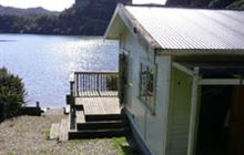
Follow the south-western arm of the Whangaroa Harbour to the Lane Cove Hut, day shelter and toilets in Pekapeka/Ranfurly Bay. If you have not booked the Lane Cove Hut, respect the privacy of hut users but feel free to use the toilets and day shelter provided.
The Wairakau Stream Track then heads up to the Kairara Rocks along the Duke’s Nose (Kaiaraara Rocks) Track to stunning views of the Whangaroa Harbour and beyond.
10,000 Steps Northland: This track equates to about 7,466 steps.
By land
Travel north on SH10, turn right onto Totara North Road towards Totara North. Turn left into Campbell Road. The Wairakau Stream Track starts approximately 400 metres along Campbell Road. Stop at the gate/stile and park well off the road on the grass verge.
By sea
The Wairakau Stream Track can also be reached by sea. The end of the track is located in Lane Cove at the western end of the Whangaroa Harbour.
- If you have booked to stay at Lane Cove Hut, you will need to bring a portable stove, food and drink, sleeping bag and cooking utensils. You may wish to boil the water before drinking.
- Fires are not permitted due to the risk they pose to kiwi and other wildlife.
- Carry warm, waterproof clothing, and food and drink, even on short walks. Stout shoes or walking boots are advisable.
- Before leaving for your walk, make sure your vehicle is locked and any valuables out of sight.
- Do not cross the Wairakau Stream during or after heavy rain as it can become swift and deep. Either wait for the waters to subside, return the way you came or go to Lane Cove via boat. Private vessels can launch from either the Totara North or Whangaroa boat ramps.
Contacts
| Pewhairangi / Bay of Islands Office | |
| Phone: | 0800 275 362 |
| Fax: | +64 4 471 1117 |
| Email: | bayofislands@doc.govt.nz |
| Address: |
34 Landing Road Kerikeri 0230 |
| Postal Address: |
PO Box 128 Kerikeri 0245 |
| Full office details | |