Okuratope pā is located 2 km west of the Te Waimate mission station, inland Bay of Islands.
Public access is difficult. There is no formed track, and public right of way is through a swamp.
Okuratope pā is one of the key pā of the contact period, strong relations to the missionary farm at Waimate North.
The pā is located between two streams and is protected under a canopy of native bush.
The features of the pā are defensive ditches. The tihi (platform) has rectangular house areas that are surrounded by ditches and small bell-shaped storage pits.
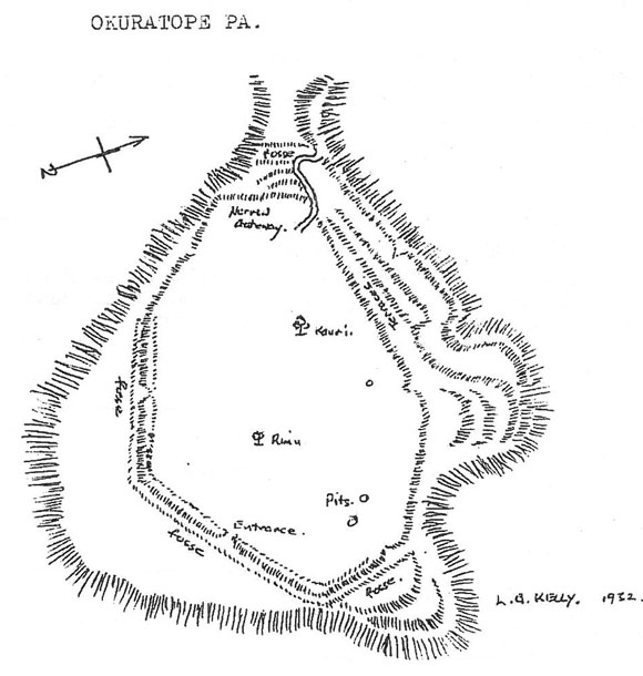
Plan of Okuratope pa
View larger (JPG, 60K)
The site is highly significant to Ngāpuhi as it is connected to several of their great leaders. In the early 19th century, Okuratope was the strong hold of Hongi Hika and his half-brother Kaingaroa.
The pā is described in great detail by early European explorers. Missionary leader Samuel Marsden and John Nicholas visited the pā with Hongi in 1815, and were impressed by its defences of the pā, which had been developed for musket warfare, the number and size of the buildings and the elevated throne of Kaingaroa. They estimated the population to be between 200-300 people.
References
Maingay, J., Robinson, J. 1994. Conservation Proposals for Okurtope Pa Historic Reserve. Department of Conservation, Northland Conservancy.
Elder, J. (ed.) The letters and Journals of Samuel Marsden, Chapter 2.
DOC Customer Service Centre
| Phone: | 0800 275 362 |
| Email: | bayofislands@doc.govt.nz |
| Address: | Pewhairangi / Bay of Islands Office |