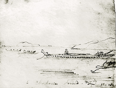
John Barnicoat sketch, Queen Charlotte Sound, March 1843
Image: Nelson Provincial Museum ©
Good on you for taking the sidetrack up to Onahau Lookout – just look at the views!
From this 417 metre high trig point you can see three sounds – Queen Charlotte Sound/Tōtaranui, Kenepuru Sound, and Mahau Sound. It's easy to see why the waterways are the main highways in this part of the country.
Getting about in boats has been the chosen mode of transport around these parts since Māori first arrived some 800 years ago.
Te Tau Ihu o Te Waka tribespeople were excellent paddlers. They would position waka (canoes) at key locations to enable efficient travel; for example, on either side of Portage Saddle/Tōrea Moua Saddle, to utilise both Kenepuru and Tōtaranui sounds. Many an enemy was caught in surprise when waka made quick work of covering long distances within the Sounds.
From the earliest days of European settlement, rowboats, sailing ships and later steam ships have plied the waters of Queen Charlotte Sound/Tōtaranui.
Stories tell of farming families rowing from Arapaoa Island and Endeavour Inlet to Picton, to collect supplies and attend social functions. George MacDonald, grandson of Endeavour Inlet landowner Peter Hohua MacDonald (Rangitāne), recalled: "It'd take them a day to row up and a day to row back".
Today's launch services leaving from the Picton waterfront continue the tradition of serving Sounds residents and tourists. The 'main highway' between the North and South islands can be observed from many parts of the Queen Charlotte Track – in the form of ferry ships.
The passenger, vehicle and freight ships utilise Tory Channel/Kura Te Au and Queen Charlotte Sound/Totaranui as they pass Dieffenbach Point/Koutounui navigation light, plying back and forth between Wellington and Picton.
Speed restrictions to the ferry ships were imposed in the early 2000s, following erosion attributed to the "fast ferries". Many Marlborough Sounds residents protested long and hard to get these restrictions.