The reserve is located midway between Blenheim and Nelson, on SH6, 18 km west of Havelock.
- Cats, dogs and any other domestic animals are not allowed in the reserve.
- Always carry warm, waterproof clothes, especially on longer walks. Take care when the tracks are wet or the river flooded. Remember your safety is your responsibility.
- Fires are not permitted in the reserve.
- Watch out for wasps, especially on the trunks of beech trees in late summer and autumn.
- Protect the reserve’s clean waters. Use toilets where provided and keep soap out of rivers and streams.
- Mountain bikes are not permitted in the reserve. The nearby Maungatapu Track is a popular ride between the Pelorus Valley and Nelson.
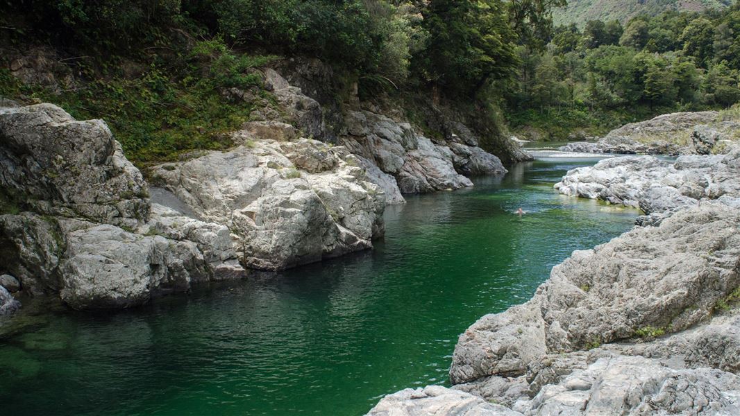
Water safety
If you plan to enjoy the water, learn how to stay safe when swimming, boating and fishing.
The vegetation in the reserve provides an excellent example of the type of fertile lowland forest which extended through the valleys of the region before European settlement. A mosaic of beech, podocarp and broadleaf species make up the forest, their distribution reflecting local variations in environmental conditions.
Black beech is abundant on steeper slopes while hard beech is more common on the spurs and the more rounded slopes. On the moister and more fertile river terraces, the emergent crowns of podocarps: rimu, mataī, miro, tōtara and kahikatea, tower over a hardwood canopy of kāmahi, mixed beech, hīnau, broadleaf and tawa, the latter reaching its southern limit here. Closer to the ground is a variety of shrubs, saplings, ferns, mosses and liverworts.
It is home to a variety of forest birds, both native and introduced. Although not always easy to see, their delightful songs can often be heard. A population of endangered native bats also roosts in the area and is the subject of a pest control trapping programme to assist in their protection.
The Te Hoiere/Pelorus River drains a large, mostly forested catchment. The water is of a high quality and provides valuable habitat for many native plants and animals, as well as introduced trout.
Early Māori settlement
A succession of Māori tribes inhabited the area for several hundred years before the arrival of Europeans. With marine and forest food in bountiful supply, coastal sites were favoured for settlements, while a network of tracks criss-crossed the less inhabited interior.
A small kāinga (village), Titi Raukawa, was situated at the junction of the Rai and Te Hoiere/Pelorus rivers. The forest and rivers provided a natural larder for the settlement. There is also evidence of cultivation of the lower river flats.
Conflicts in the area in the 1820s caused significant population loss, and early European explorers found only a few native inhabitants.
European settlement
Originally known to Māori as Te Hoiere, the Pelorus Sound and River were renamed following a visit to the area by Lieutenant Phillip Chetwode in the Royal Navy brig HMS Pelorus, in September 1838.
Following the European settlement of Nelson in 1842, the area was further explored for possible routes linking Nelson to the Wairau Valley. A Māori route leading over Maungatapu Saddle and down into the Pelorus Valley was developed into a bridle track, completed in 1859. Known then as ‘The Moketap’, the route was extensively used by settlers and travellers. In 1864 it carried a rush of hopeful prospectors to the new goldfield at Wakamarina.
In 1863 the first Pelorus Bridge was built. Then, in 1885, the year the second bridge was built, the route followed by the modern road (over Whangamoa and Rai Saddles) opened. The first coach trip between Blenheim and Nelson was completed in April of that year by William Pickering, who had operated a coach service between Blenheim and Havelock since 1879.
In the early 1880s the Pelorus Valley was still largely forested. The innovative William Brownlee built a bush tramway and sawmill in 1881. Over the next 25 years he milled most of the lowland forest, opening up land for settlers in the process. The site of the current reserve was spared only because it had been set aside for a township in 1865. Plans for the town were delayed and in 1912, with a slowly increasing awareness of the value of natural areas, a scenic reserve was created.
Nelson/Tasman/Marlborough information
| Phone: | +64 3 546 9339 |
| Email: | nelsonvc@doc.govt.nz |
| About: | Whakatū/Nelson visitor services provide information for this area |