May to end of September (winter season): The Whanganui River journey should only be attempted out of the Great Walks season by people who are very experienced in canoeing remote New Zealand rivers in winter.
Check if this trip is right for you
This trip is very different to other Great Walks – it’s a paddle, not a walk. Think carefully about if it’s right for you. To do the Whanganui Journey safely without a guide, you should:
- be a confident swimmer
- have experience in a canoe
- be fit enough to paddle for 6 to 7 hours in a day
- be over the age of 10
- have at least two people in your group, plus enough adults to look after any children and teens if something goes wrong.
If you aren’t an experienced canoe user or are travelling alone, book a guided trip instead.
If you can’t swim or aren’t fit enough, then this isn’t the trip for you. There are lots of other great adventures in Whanganui National Park.
Highlights
- Enjoy the Wanganui River in a canoe or kayak.
- Take a break from the water on a short walk to the Bridge to Nowhere.
- Be immersed in culture and history with a unique stay at Tieke Kainga, the only DOC hut that is also used as a marae.
Watch videos of the Whanganui Journey
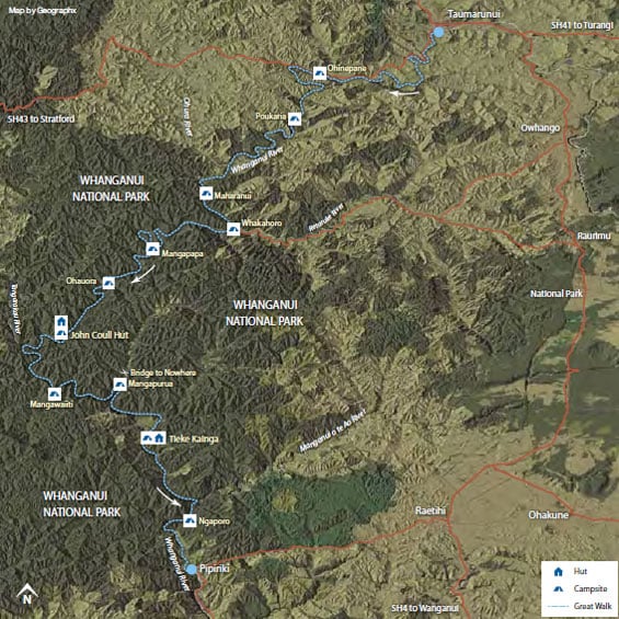
Distances between campsites and huts
- Cherry Grove, Taumarunui to Ohinepane campsite — 22 km
- Ohinepane to Poukaria campsite — 14 km
- Poukaria to Maharanui campsite — 17 km
- Maharanui to Whakahoro campsite and Whakahoro Bunkroom— 4 km
- Whakahoro to Mangapapa campsite — 11 km
- Mangapapa to Ohauora campsite — 16 km
- Ohauora to John Coull Hut — 10.5 km
- John Coull Hut to Mangawaiiti campsite — 9.5 km
- Mangawaiiti to Mangapurua campsite — 9 km
- Mangapurua to Tīeke Kāinga — 10.5 km
- Tieke to Ngaporo campsite — 12.5 km
- Ngaporo to Pipiriki — 9 km
Trip options
The 145 kilometre river journey from Taumarunui to Pipiriki takes an average 5 days to complete by canoe. A shorter 3 day journey from Whakahoro to Pipiriki is also possible.
Each trip requires a good level of fitness and confidence in using a canoe.
For a 5 day / 4 night trip:
- Day 1 and 2 – Taumarunui to Whakahoro
- Day 3 – Whakahoro to John Coull Hut
- Day 4 – John Coull Hut to Tīeke Kāinga
- Day 5 – Tīeke Kāinga to Pīpīriki
Taumarunui to Whakahoro
Distance: 57 km
Access points are at Ngāhuinga (Cherry Grove) in Taumarunui or further downstream at Ōhinepane (accessed from River Road SH43).
Travelling the upper reaches of the Whanganui River, you’ll pass through a mixture of farmland and patches of native bush. You’ll be in for some excitement as you shoot down rapids on this section of the river.
Camp beside the river at Ōhinepane, Poukaria or Maharanui campsites or stay in a campsite or bunkhouse at Whakahoro. From here, you get the feeling of venturing into the heart of a rich and rugged landscape.
Whakahoro to John Coull Hut
Distance: 37.5 km
Many begin their river journey here – the scenic middle reaches of the river, featuring numerous waterfalls after heavy rain. Past Mangapapa Campsite, take a long loop around the Kirikiriroa Peninsula, pass the Tarepokiore (whirlpool) rapid and then the large overhang known as Tamatea’s Cave.
Please do not enter the cave as it is wāhi tapu (a sacred place). Ōtaihanga Reach leads you to your overnight stop at John Coull and Campsite and John Coull Campsite.
You may see long-tailed bats fluttering overhead at dusk.
John Coull Hut to Tīeke Kāinga
Distance: 29 km
On this section, follow the river as it meanders through bush-covered hills, passing the mouths of the Tāngārākau and Whangamōmona rivers where they join the Whanganui. Perched high above the river, Manga-wai-iti is an attractive spot to camp or stop for lunch.
Continue your trip downstream to Tīeke Kāinga where you can examine the intricately carved pou whenua and learn about the history of Tīeke and the tikanga (protocol) of the marae.
Tīeke Kāinga information and tikanga (protocol).
Alternative accommodation option
For a more secluded night’s sleep, stay at Puketotara Hut. Opposite Tieke Kainga, this 1 hr and 30 min track takes you high up on the Matemateaonga Range where you will spend the night in podocarp splendour, with expansive views of the Whanganui River, the bush clad hills of Whanganui National Park and the volcanoes of the Central Plateau.
Side trip: Bridge to Nowhere
At Mangapurua Landing, where the old riverboats used to tie up, hop out of your canoe and take the 40-minute (one way) Bridge to Nowhere Walk to this poignant reminder of the Mangapurua Valley farm settlement, carved out of the bush and then abandoned between the two World Wars.
Exercise caution when disembarking and embarking. The Landing can become very congested with canoes and boats. The rock surface is very slippery when wet.
Look out for cyclists – the track is also part of the Mountains to Sea Cycle Trail.
Tīeke Kāinga to Pīpīriki
Distance: 21.5 km
You’ll pass through the scenic gorge of the Manganui o te Ao River where it enters the Whanganui after its journey from the slopes of Mount Ruapehu. Ngāporo and Autapu rapids can provide plenty of excitement and perhaps a cool dip on a hot day.
More exotic trees and farmland indicate you are getting close to Pīpīriki. Pass an eel weir on your left, shoot the Paparoa rapid and you will see the boat ramp below Pīpīriki village up ahead.
