Complete this loop in the direction described below. Te Tihi o Ruru and Te Ranga Tracks are one-way for mountain biking.
Maunga Kākaramea car park to crater lake lookout
- 500 m
- Grade 2 mountain biking
- Easy short walk
From the Maunga Kākaramea car park, follow signs to the crater lake lookout.
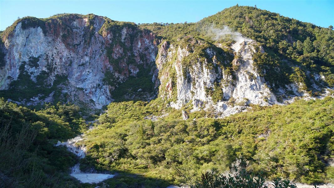
Bikes are not allowed on the 30 m side track to the viewing platform. From the lookout, there are views over a crater lake and brown, orange and red steaming cliffs.
Te Tihi o Ruru Track (crater lake lookout to summit/Te Ranga Trail)
- Grade 4
- 3 km
- Easy to intermediate walking track
- Uphill biking only
The track climbs through regenerating native vegetation and past the bare, coloured and steaming ridges. The climb is sustained, steep and technical.
Shortly before the summit, you will reach the turnoff to Te Ranga Trail.
The summit is an extra 200 m up the hill. On a clear day at the summit, you can see Mt Tarawera in the north, Paeroa Range to the west and the volcanic peaks of Tongariro National Park to the south.
Te Ranga Trail - summit to Te Ranga (Kerosene Creek)
- Grade 4
- 3 km
- No walkers
- Downhill biking only
Te Ranga Trail is a challenging, technical descent through a unique geothermal environment.
The top third is the most technical and has been hand-built to minimise impacts on the sensitive geothermal environment. The lower two-thirds flow through regenerating bush. This section has been machine-built with more riding features and good flow.
The track ends at Te Ranga (Kerosene Creek), a naturally warm creek. There are toilets, a car park and an information shelter here.
If bathing in the creek, check the temperature before getting in. Do not put your head under the water because of the risk of amoebic meningitis.
Te Ranga (Kerosene Creek) to crater lake lookout
- 3.5 km
- Grade 2
- Easy to intermediate walking track
The track passes through regenerating bush and has good views of active geothermal areas and the Wai-o-Tapu geothermal field.
The combination of native forest, steaming landscapes, and elevated viewpoints makes this a unique track that highlights the powerful volcanic forces that continue to shape the area.
Crater lake lookout to Maunga Kākaramea car park
- 500 m
- Grade 2 mountain biking
- Easy short walk
Follow the track back to the car park.
Maunga Kākāramea is particularly significant to the local iwi Ngāti Tahu/Ngāti Whaoa. Stay on the formed tracks to respect this place and protect rare geothermal plants.
This loop starts at Maunga Kākaramea car park. You can get there:
- By bike on Te Ara Ahi Cycle Trail
- By car. The car park is on SH5 by Maunga Kākaramea. From Rotorua, it is on the left-hand side of SH5, 500 m past the junction with SH38.
Safety and hazards
- Fragile and dangerous geothermal landscape
- Cliffs and high drop-offs on this track
- Stay on the track and behind barriers
- Supervise children
- The track is steep, rough and eroded in places. The clay surface becomes very slippery in wet weather.
- Watch for vehicles on the summit road.
Shared use tracks
- Te Ranga Trail is for downhill mountain biking only.
- All other tracks in this loop are shared by walkers and mountain bikers.
Toilets
Toilets are at the Maunga Kākaramea car park and Te Ranga (Kerosene Creek).
Maunga Kākaramea is home to rare and threatened geothermal plants.
Plants growing here have needed to adapt to the high temperatures, acidic soil and toxic gases. They have developed special characteristics to survive, like shallow roots, needle-like leaves and slow growth. Some mosses, liverworts and lichens can live in temperatures as hot as 70°C.
The geothermal activity on Maunga Kākaramea has cooled over the last 100 years. This has reduced the soil temperature and so means the forests are coming back.
Maunga Kākaramea means ‘mountain of coloured earth'. You can see these colours in the cliffs.
The summit and slopes of Maunga Kākaramea supported a large Pā. During times of battle women and children were moved to the summit area while the fighting warriors occupied more strategic slopes allowing them to engage in battle more effectively.
One of the last major battles in this area was when the Raukawa chief Rahurahu made an attack on the Ngāti Tahu-Ngāti Whaoa people. He was lured into this area where a large party of Ngāti Tahu, Ngāti Whaoa and Ngāti Apumoana were waiting for him. It was in this battle that Rahurahu was finally defeated.
DOC Customer Service Centre
| Phone: | 0800 275 362 |
| Email: | rotorua@doc.govt.nz |
| Address: | Rotorua Office |