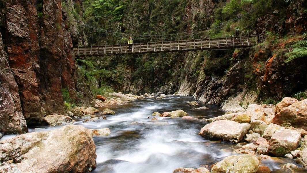
Karangahake Gorge combines gold mining history and natural beauty, much of it is accessible through a variety of walks.
The Kaimai Mamaku Conservation Park stretches from Karangahake Gorge in the north, almost to Rotorua in the south. The park is bordered by state highways 2, 26, 27, 29 and 36.
The nearest towns are Paeroa, Waihi, Katikati, Tauranga, Matamata and Te Aroha. These are all serviced by regular buses, and Air New Zealand runs services to and from Tauranga airport.
Weather
Weather for Kaimai Mamaku Conservation Park - Bay of Plenty rural forecast
Fires
Fires are a hazard to any bush area. No fires may be lit in the Kaimai-Mamaku Conservation Park without a permit.
The high northern part of the Kaimai range is comprised of ancient volcanic rock which has been uplifted along the Hauraki fault line. The range is covered by a sheet of volcanic rock called ignimbrite.
The Mamaku plateau to the south is a flat sheet of ignimbrite which erupted from the site of Lake Rotorua 140,000 years ago.
Flora and fauna
The area hosts a great range of vegetation from dense low altitude forest to windblown scrub and grassland. The park marks the northern limit of kamahi, red beech and silver beech. It is the southern limit of the mighty kauri. This unusual combination of semi-coastal and montane plant species makes the forest composition unique and highly significant.
The park is the natural home of native birds such as whitehead, whio/blue duck, kaka, kokako, kiwi and karearea/New Zealand falcon. More common native birds such as tui and bellbirds are readily seen and heard from within the park.
Small remnant populations of the endangered kiwi and kokako are found in the northern Mamaku. Small populations of the endangered Hochstetter’s frog are found scattered throughout the northern half of the park.
Both long- and short-tailed bats are present, along with the threatened striped skink and some rare invertebrates including the Mount Te Aroha stag beetle, plus snails such as Paraphantabusbii busbii (the kauri snail).
Introduced animal pests such as possums, goats, pigs, deer, mustelids and rats threaten forest health and the ongoing survival of native species. DOC carries out pest control at key sites and encourages recreational hunting to assist with pest control.
Much of the vegetation in the park has been modified by human activity. In the late 1880s the gold mining industry generated huge demand for timber. Kauri were extracted from the Kaimai in large numbers for use in mine construction and for fuel in gold extraction processes.
Along with other reserves in the area, the park encompasses the remains of the unique natural heritage of this part of New Zealand.
The areas protected by the Kaimai Mamaku Conservation Park are significant to the iwi of Tainui, Takitimu and Mataatua waka.
Far back in time Mount Te Aroha, the highest point in the Kamai Mamuku Conservation Park (952 m), gained its name in Māori legend. One story tells how the Arawa chief, Kahumatamomoe was on his way home from visiting a kinsman at Kaipara. As was the habit of this explorer, he ascended to the highest possible point along the way. As he stood on top of the mountain, he decided to name it “Aroha ki tai”. This was an expression of his love for his father, who was buried on Mount Moehau and his family who lived at Maketu. There are other legends relating to the naming of the mountain.
To early Māori inhabitants and later Europeans, the Kaimai mountain range formed a barrier between the Bay of Plenty and Waikato regions. Traversed by rough tramping routes and later by access tracks for the logging and gold mining industries, the Kaimai range now features over 360 km of walking and tramping tracks.
Mining heritage
The Tui Mine area, on the northern slops of the mountain, was mined to provide lead flux for the Waiorongomai smelters. However, the ore contained too much zinc to be of use. In the 1960s the area was extensively mined but the venture failed due to mercury contamination of the ore. The most significant result of this period is the presence of the large tailings heap on the site. The tailings amount to approximately 100,000 tonnes. The combination of high heavy metal concentration, porous tailings and acidic leachate has created an inhospitable environment where plants have been unable to establish.
Traces of gold were discovered on Mount Te Aroha in 1880. Prospectors burnt much of the native vegetation looking for a gold bearing reef, which was never found. Their attention turned to Waiorongomai when Buck Reef was discovered. The mining remains at Waiorongomai are a short drive from Te Aroha and are well worth a look.
Victoria Battery Site in Karangahake Gorge was the largest gold ore crushing battery in New Zealand
The Waiorongomai Valley is a significant gold mining site in the Kaimai Mamaku Conservation Park.
Piako County Tramway was built in 1882-83 and is New Zealand's oldest bush tramway with the original rail still in place.
DOC Customer Service Centre
| Phone: | 0800 275 362 |
| Email: | taurangainfo@doc.govt.nz |
| Address: | Tauranga Office |