Te Henga Walkway
Located in Muriwai and Te Henga area in the Auckland region
|
Introduction
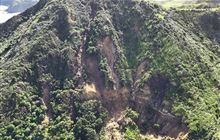
The walkway is closed and inaccessible due to large slips and landslides throughout the track.10.3 km one way
Walking and tramping
3 hr 20 min one way Easy: Walking trackIntermediate: Great Walk/Easier tramping track
Dog access
Time and distance
- Bethells Road to O’Neill Bay: 2.1 km / 40 min one way
- Bethells Road to Raetahinga Point: 4.1 km / 1 hr 20 min one way
- Bethells Road to Constable Road: 10.3 km / 3 hr 20 min one way
Track categories
The Bethells Road to Raetahinga Point section is categorised as Easy: Walking track.
From Raetahinga Point to Constable Road the track is Intermediate: Easier tramping track.
Track description
The track follows coastal cliffs and is rutted and steep in sections. It becomes slippery after periods of rain. Take care around old slip sites.
From Bethells Road the Te Henga Walkway crosses the Waitākere River by footbridge, rising along a graded section, to superb views of lagoons, dunes and the west coast surf down to O’Neill's Bay, where you can return along Bethells Beach.
To continue along Te Henga Walkway, the track climbs steeply then follows along the cliff-top where you may see gannets diving for fish. The track exits through a farm valley and another steep climb to Constable Road. Care is needed on this track, which traverses coastal cliffs and is uneven and muddy in places.
Hillary Trail
This track is part of the Hillary Trail which connects a network of existing tracks and basic backpacker campgrounds in the Waitākere Ranges.
It takes trampers through the Waitākere Ranges, past the Arataki Visitor Centre, Huia, Whatipu, Karekare, Piha, Anawhata, and either winding north to Muriwai via the Te Henga Walkway, or through Cascade Kauri Park and onto Swanson.
The southern entrance is off Bethells Beach (Te Henga), 37 km from downtown Auckland. The track is signposted near a bridge 1 km before the end of Bethells Rd opposite Lake Wainamu carpark.
The northern entrance to Te Henga Walkway is from Constable Rd, off Oaia Rd, Muriwai. The northern entrance is 46 km from downtown Auckland.
No cycling on the track.
The beach can be dangerous
Auckland’s West Coast beaches are beautiful but can be dangerous. Each year several people drown here and hundreds have to be rescued.
Visitors must be aware of the dangers and take steps to ensure their own safety.
Visit Surf Life Saving NZ – stay safe for more information on beach safety.
Take care on the track
Track crosses private land. Keep to the track and be careful around stock.
Parts of the track may be overgrown with gorse and flax.
Be aware of dangers on the tracks and surrounding areas including clifftops.
Contacts
Tāmaki Makaurau / Auckland Visitor Centre | |
Phone: | +64 9 379 6476 |
Email: | aucklandvc@doc.govt.nz |
Address: |
No physical address Contact via email or phone |
Postal Address: |
PO Box 32026 Devonport Auckland 0744 |
Full office details |