Status: superior
The water in Paterson Inlet/Whaka a Te Wera is cold (annual average is 11.4 °C), with good visibility. Water from the Pacific Ocean moves in and out of the inlet, driven by wind and tides. The level of sedimentation in the inlet is comparable with levels that would have been found in many parts of New Zealand in pre-human times.
Freshwater River, the largest freshwater source entering the inlet, is in pristine condition. It contains very low levels of sediment and contaminants because of its natural native forest catchment. This fresh water is acidic (pH 4–5), stained dark brown with tannins and contains soluble iron (approximately 0.8 mg/L). After heavy rain, the discoloured stream water can reduce light penetration in the inlet for several days.
Marine farms operate in Big Glory Bay, a southern arm of Paterson Inlet. 38 mussel licences and 2 salmon licences were current for this bay in 2016. Marine farms are situated about 3.5 km from the marine reserve.
Trend: stable
No significant changes in water quality have been reported in the last five years.
Monitoring
No regular water quality monitoring is undertaken in the marine reserve. Environment Southland has a biomonitoring site on Mill Creek in the town of Oban and two coastal contact recreation sites in Halfmoon Bay, but does not currently carry out regular monitoring.
Water quality monitoring is carried out in Big Glory Bay under the New Zealand Food Safety Authority’s Animal Products (Specifications for Bivalve Molluscan Shellfish) Notice 2006 (PDF, 330K) as a requirement for marine farming in the area. This food safety standard states the frequency and limits for a range of possible contaminants and is used here as a measure of ecosystem health.
Testing for faecal coliforms and the bacterium E.coli is carried out monthly, sampling for biotoxins (the cause of algal blooms) is carried out weekly and the levels of heavy metals are surveyed every three years. Levels of these contaminants in Big Glory Bay are consistently below the upper limits of the standard.
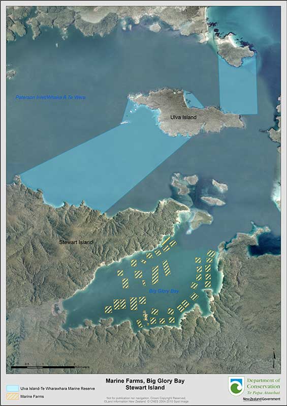
The distance from the marine farms in Big Glory Bay in Paterson Inlet to the closest boundary to the marine reserve (3.1 km and 3.6 km)
Reports
- Freshwater Estuary Fine Scale Monitoring 2012/3. Prepared for Environment Southland by Barry Robertson and Leigh Stevens.
- Literature review of ecological effects of aquaculture (PDF, 1,972K). Ministry for Primary Industries 2013.
- Environment Southland – Review of State of the Environment Water Quality Monitoring Programme, April 2010. By Aquanet Consulting Ltd.
- Stewart Island Non-Indigenous Species Port Survey (surveying work was carried out in 2006). Prepared for MAF Biosecurity New Zealand.
- Advice on the Development of Appropriate Monitoring Conditions for Marine Farm Sites in Southland (PDF, 3,540K). Cawthron report 2008.
- A study on salmon farming in Big Glory Bay (PDF, 1,930K) was produced by the DSIR for the Southland Catchment Board (Roper et al. 1988).