This hunting area is covered by an 'open area permit' – get it online.
About this hunting block
General information
The Diadem Range consists of open tussock country, within Ahuriri Conservation Park. Red deer, chamois and sometimes tahr are found in this block.
Access
Access via the easement
Important: This acccess requires wading across the Ahuriri River. Check river levels and conditions before crossing.
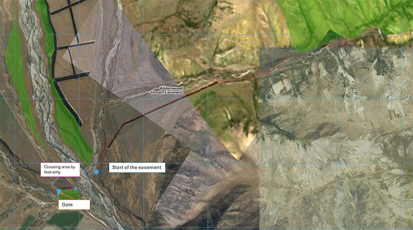
To reach the easement, drive on the true right of the Ahuriri River via Birchwood Road. Cross the first bridge on Birchwood Road (signposted 'Ahuriri River – This Way').
After crossing the bridge, you may drive through a gate on the right-hand side of the road and park your vehicle on the area of public conservation land on the west side of the river. It is foot access only from here.
The easement is located on the opposite side of the river, near the confluence of Ribbonwood Stream and the Ahuriri River. Once across, stay on the true left of Ribbonwood Stream. Look for an orange marker across the fence and follow the track, watching for the next marker.
The easement follows the track along the shelterbelt for about 2 km, then keep following the fence line until you reach a gate with a public conservation land sign.
- Firearms must be carried unloaded on the easement.
- Hunting is not permitted on access easements that cross private land.
Map showing access track (JPG, 183K)
Maps
NZTopo50 CA14 Lindis Pass, BZ14 Mount Barth
Dogs
No dogs are allowed.
Additional information
Respect private property
The easment track crosses private land. No hunting on private land. Respect the landowner's livestock and property. Stay on the marked track until you reach public conservation land. Leave gates as you find them and use stiles where provided. Livestock can be unpredictable – keep your distance at all times.
No camping until the conservation area boundary.
DOC Customer Service Centre
| Phone: | 0800 275 362 |
| Email: | info@doc.govt.nz |
| Address: | Te Manahuna / Twizel Office |