The Legislative Basis for the New Zealand Conservation Authority (NZCA) submission
- The New Zealand Conservation Authority (NZCA) was established under the Conservation Act 1987, with members appointed by the Minister of Conservation. It is an independent statutory body with a range of functions, but primarily acts as an independent conservation advisor to the Minister and the Director-General of Conservation.
- The NZCA has a role as an objective advocate on matters of national significance and interest in the conservation arena and to provide high quality independent advice to the Department of Conservation (DOC) on its strategic direction and performance.
- The NZCA has a range of powers and functions, under the Conservation Act 1987, as well as under other conservation related legislation. Under section 6C(2)(c) of the Conservation Act, the NZCA has the power to “advocate the interests of the Authority at any public forum or in any statutory planning process.”
- The NZCA naturally holds an interest in this topic due (in addition to the above) to its role and responsibilities as the “owner” of the General Policy for National Parks and as the driver in the process of adding land parcels to National Parks. The NZCA must adhere to due process outlined under the National Parks Act 1980 and, pursuant to section 18(e), provides advice to the Minister on recommendations of land parcels that could be added to National Parks.
- In exercising its functions under the Conservation Act and Acts listed in Schedule 1 of the Conservation Act, the NZCA is subject to the obligation arising in section 4: that the Act and Schedule 1 Acts are to be interpreted and administered as to give effect to the principles of the Treaty of Waitangi. The NZCA has given particular consideration to section 4 in producing this submission.
- In accordance with the above powers and functions, the Authority wishes to present observations and recommendations though this submission.
NZCA Submission
- The NZCA submission is based on its analysis of the:
- Conservation Act 1987 (Act) and National Parks Act 1980 (NPA)
- Conservation General Policy (CGP) and General Policy for National Parks (GPNP)
- Consultation documents for the proposed recommendations for reclassification of stewardship land on the West Coast, available on DOC’s website.[1]
- Discussion with the National Panel Chair and Mana Whenua Panel Chair at the NZCA’s June 2022 meeting, and with DOC officials at the August 2022 meeting.
Background
- The NZCA has remained well informed on the progress made regarding the stewardship land reclassification project and the various stages of its development, having been briefed by DOC on various occasions at its bi-monthly meetings.
- The NZCA notes that, in 2016, the Department initiated what was to be a five-year project to reclassify blocks of stewardship land across the country, in response to criticism from the PCE for ongoing delays in undertaking the work.[2] As part of that process, the 15 Conservation Boards were asked to provide recommendations to DOC on the top five Stewardship Land areas in their respective regions to be considered for reclassification. The NZCA was concerned that having undertaken significant research to identify the land parcels, the Department never progressed the project.
- The table below contains the top five priority recommendations from the West Coast Tai Poutini Conservation Board in 2016, compared to the recommendations made by the two panels in the current project:
|
WCTPCB Recs (2016) |
||||||
|
Protected Area Name |
National Panel Recs |
Mana Whenua Recs |
Priority level |
Recommendation |
||
|
Conservation Area - Birchfield |
Wildlife Management Area |
Neutral |
1 |
TBD |
||
|
Conservation Area - Birchfield East Wetland |
Wildlife Management Area |
Neutral |
1 |
TBD |
||
|
Conservation Area - Granity |
Wildlife Management Area |
Neutral |
1 |
TBD |
||
|
Conservation Area - Waimangaroa - Granity |
Conservation Park (Waimangaroa) |
Stewardship |
2 |
TBD |
||
|
Conservation Area - Mount Rochfort |
Conservation Park (Whareatea) |
Stewardship |
2 |
TBD |
||
|
Conservation Area - Barrytown Flat |
Scenic Reserve (a) |
Neutral |
3 |
Nature/Scenic Reserve |
||
|
Conservation Area - Charleston Cemetery Road |
Scenic Reserve (a) |
Disposal |
4 |
Addition to Paparoa NP |
||
|
Conservation Area - Charleston - Cemetery Road |
Scenic Reserve (a) |
Disposal |
4 |
Addition to Paparoa NP |
||
|
Conservation Area - Eleven Mile Creek |
Scenic Reserve (a) |
Neutral |
5 |
Addition to Paparoa NP |
||
|
Conservation Area - Paparoa Range South |
National Park (Paparoa) |
Stewardship |
5 |
Addition to Paparoa NP |
||
- The NZCA has previously provided a report to the Minister in 2016, updated in 2018, entitled Stewardship Land: Net Conservation Benefit Assessments in Land Exchanges, which outlined the ability to progress these processes within the current legislation. The current project could be seen as a knee-jerk solution driven by ongoing criticism for failing to attend to the issue.
- At its June 2022 meeting, the NZCA was joined by DOC staff and panel Chairs, Neil Clifton (Chair of the Western South Island National Panel) and Francois Tumahai (Chair of the Ngāi Tahu Mana Whenua Panel), who provided information on how the two panels worked together throughout the process and how the recommendations were determined.
- There appears to be a significant difference in recommendations between the national and mana whenua panels, excluding those where the Manawhenua Panel were neutral:
|
National Panel Rec |
Mana Whenua Rec |
Total differing recs |
|
National Park |
Stewardship Land |
47 |
|
Conservation Park |
Disposal |
12 |
|
Conservation Park |
Stewardship Land |
9 |
|
Wildlife Management Area |
Disposal |
4 |
|
Scenic Reserve |
Disposal |
4 |
|
Local Purpose |
Stewardship Land |
3 |
|
National Park |
Disposal |
2 |
|
Recreational Reserve |
Disposal |
2 |
|
Scenic Reserve |
Stewardship Land |
1 |
|
Wildlife Management Area |
Stewardship Land |
1 |
- Given the variation in stances, the NZCA would support a cautionary approach to reclassification and preference to retain Crown ownership over disposal. While the work and reports prepared are helpful, the fundamental differences need to be channelled into processes where they can be worked through; the stewardship land process seems it may lack the tools to resolve these bigger issues.
- The NZCA acknowledges the extension of timeframes for public submission, given the original timeframe was inadequate and problematic given the extent of the land area covered, and conflicting interests involved.
- Even in this longer timeframe, the NZCA is not in a position to prepare a submission based on trawling through all the reports on each land parcel. In recognising the role of NGOs, such as Forest & Bird and Federated Mountain Clubs (FMC), to conduct finer analysis of these recommendations, the NZCA is disappointed in the time constraints implemented by the Department. Iwi organisations, many who are more poorly resourced, may well be placed under considerable pressure to submit.
- In addition, the parallel process of proposed legislative streamlining for Stewardship Land is ongoing, with public consultation taking place over four months, between November 2021 and March 2022. The NZCA is of the view that the summary of submissions on the Discussion Document: Stewardship land in Aotearoa New Zealand: Options to streamline processes for reclassification and disposal should have been released before this second stage of consultation was undertaken.
- In this submission, the NZCA will explore its priority concerns regarding the recommendations for stewardship land reclassification in the Western South Island, namely:
- The position of Te Rūnanga o Ngāi Tahu on National Park status and the role such status has in alienating mana whenua from their ancestral lands.
- Crown failure to uphold promises made in relation to National Parks
- The robustness of the stewardship land classification recommendations and the process to determine them.
- We then go on to assess the land parcels proposed to be added to the National Parks, and describe other blocks where we disagree with the recommendations of the panels, and feel they should be added to a national park.
The position of Te Rūnanga o Ngāi Tahu, regarding National Park access
- Francois Tumahai presented to the June 2022 NZCA meeting. He expressed that Te Rūnanga o Ngāi Tahu holds a firm stance on protecting the customary rights of mana whenua to use the land for cultural harvest. Therefore, Ngāi Tahu are very reluctant to add parcels of land to existing National Parks, arguing the National Park status alienates the rights of mana whenua to practice cultural activities such as mahinga kai. That position aligns with the Summary of Mana Whenua Panel Recommendations for Tai Poutini that National Park status "Obstructs Ngāi Tahu from maintaining ancestral relationships with the whenua, obstructs kaitiaki rights and responsibilities, and is less enabling of customary practices that are fundamental to sustaining tribal identity and mana
- In light of the presentation from Mr Tumahai, and the differing recommendations from the Panels, NZCA sought further advice from DOC as to the position of Ngāi Tahu and the Mana Whenua panel. The advice we received was that Te Rūnanga o Ngāi Tahu opposes all additions to National Parks within the Ngāi Tahu takiwā and that this position is supported by the Mana Whenua panel. Further, that at this stage (prior to working through the implications of Ngai Tai ki Tāmaki) Ngāi Tahu and the Mana Whenua Panel consider it would be entirely inappropriate and in breach of section 4 to consider any additions to National Parks (Memorandum dated 25 July 2022).
- This gave NZCA considerable reservations as to whether the reclassification process could result in land being added to National Parks in a manner consistent with the Act or whether section 4 required that potential National Park additions not be addressed. That was relevant to NZCA in formulating its position and recommendations and it appeared to NZCA that it would also be relevant to the Minister in making her decisions.
- We sought further clarification around this issue which was provided at our August 2022 meeting. While we still have limited information about the nuances of the Ngāi Tahu position, we now understand that although Ngāi Tahu continues to maintain a position in principle of opposition to National Park additions, Ngāi Tahu has agreed to, and is comfortable with, the process continuing and with the Minister making decisions on all recommendations including potential additions to National Parks.
- On that basis, we understand that it would not be inconsistent with section 4 for the NZCA to take the view in this submission that land parcels which the National Panel recommended for addition to a National Park should be added to National Parks. This is addressed at paragraphs 44 – 48 below.
- The broader issue raised by Ngāi Tahu is that the rights of mana whenua to practice cultural activities on conservation lands and waters are impacted by a number of Acts and provisions, including the NPA. The conservation law reform process, therefore, seems a better avenue where such issues could be constructively addressed.
- The NZCA submits that changes allowing for uninterrupted cultural practice and customary use of tangata whenua on PCL can only be achieved through changes to conservation legislation and general policies. The NZCA notes that the programme of conservation law reform should seek to resolve such issues as a matter of priority.
- The NZCA submits that this topic needs careful consideration and discussion and must actively involve tangata whenua to produce an outcome which respects customary rights, connection and practices and addresses concerns, such as those held by Ngāi Tahu, whilst also ensuring appropriate protections remain in place for all PCL.
Crown failure to uphold promises made in relation to National Parks
- In the meantime, the NZCA notes that there are issues DOC can resolve to address Ngāi Tahu concerns which can help the overall aim of achieving section 4 obligations, and its mission to be an honourable Treaty partner.
- The NZCA was informed, by Francois Tumahai during its meeting, that the Ngāi Tahu stance is also a product of the unfulfilled promises made by the Department during the process of adding the 64,000ha Mokihinui addition to the Kahurangi National Park. In particular, the then Minister assured Ngāi Tahu that the Department would undertake the review of the Kahurangi National Park Management Plan (NPMP), given the Park had almost doubled in size, and the review would be along the lines of the recently completed Paparoa NPMP review.
- The Authority notes that:
- The Nelson/Marlborough CMS was approved in 1996 and was due for full review in 2006 (overdue by 16 years); there is no expected start date to this review.
- The West Coast Te Tai o Poutini CMS was approved in 2010 and due for a full review in 2020; the review was initiated in 2021 but there is no estimated completion date.
- Kahurangi NPMP was approved in 2001 and a full review was due in 2011. The Mokihinui Riverbed was added to the NP in 2018, and in the NZCA’s media release in 2018 we stated:
“… the Authority asked the Director-General to prioritise planning resources to the Nelson-Marlborough CMS … so that the NPMP process can be started as soon as practical. The Director-General has actioned this and we look forward to progress being made on both the CMS and NPMP soon.”
- To date, the Department has not initiated the review of the Kahurangi NPMP and has given no indication when it is likely to begin doing so. NZCA has expressed its concerns around the delays in management planning on a number of occasions. Here is a tangible example of the impact of these delays.
- The NZCA is currently seeking more information around this matter, as it presents an opportunity to work through a series of fundamental differences in the panel’s recommendations. This situation requires time and patience to resolve.
The robustness of the stewardship land classification recommendations and the process to determine them
- The NZCA believes that the panels have not been given sufficient time to investigate the parcels of land fully in order to reach robust recommendations, which is reflected in the wide range of land classifications which have been proposed by the panels, particularly the National Panel:
|
Classification |
National Panel recs |
Manawhenua Panel recs |
|
Conservation Park |
136 |
20 |
|
Historic Reserve |
31 |
25 |
|
National Park |
49 |
0 |
|
Scenic Reserve |
101 |
13 |
|
Stewardship |
8 |
69 |
|
Ecological Area |
20 |
4 |
|
Local Purpose Reserve |
96 |
19 |
|
Wildlife Management Area |
43 |
8 |
|
Recreation Reserve |
17 |
4 |
|
Disposal |
68 |
92 |
|
Government Purpose Reserve |
6 |
0 |
|
Amenity Area |
1 |
1 |
|
Neutral |
0 |
321 |
- The NZCA is concerned that a number of land parcels that include rivers, riverbeds, dunes, coastal margins, and wetlands, have not been properly considered and elevated by the National Panel; particularly, for example, in the context of climate change and increasingly volatile weather events.
- The NZCA strongly believes that waterways and the land surrounding them, such as river mouths, estuaries, wetlands, and dune systems, are very important on both a local and national level. The NZCA has noticed a continuing trend of insufficient attention being paid to these land features and systems, and these trends are also reflected in the recommendations from both panels.
- A number of land parcels extend from alpine to coastal habitats, of which some include major catchments. It is important to note that, in these significant parcels of land, the integrity and interconnection of systems is very important. The NZCA further highlights the contribution these lands can provide in terms of implementing a
mountain-to-sea strategy aimed at achieving positive biodiversity, freshwater, and marine outcomes. - The NZCA notes that Policy 6(j) of the General Policy for National Parks 2005 states:
“The inclusion in national parks of the beds of lakes and rivers vested in the Crown, within the boundaries of the national park, and of any foreshore adjoining the national park, should be sought wherever possible, as they are ecologically continuous with the national park and their inclusion would allow for better integrated management of the national park.”
- It is not always clear how a land parcel’s conservation values have been treated in light of land adjacent to it, in order to provide an integrated approach. The NZCA considers that these areas should be approached under the presumption that the land in question should be afforded the same classification as the land adjacent to it with the highest land classification, with any lesser classification requiring explanation. As it is, neither the Solution Range nor the Whataroa-Perth areas, for example, are recommended to become part of the adjacent Westland Tai Poutini National Park.
- Equally, there are large tracts of pristine wilderness (up to ca. 188,000ha), largely in the Hokitika area, that have been recommended as Conservation Park, where a more detailed analysis may recognise the need for these areas to be classified as National Park.
- The NZCA is concerned that, where adding parcels of land to National Parks conflicts with the interests of Ngāi Tahu, the proposed recommendations are to classify such land as Conservation Park. This is a permissive classification providing little to no protection for highly valued conservation land from extractive activities, such as mining and large-scale hydro generation. Additionally, once land is classed as conservation park, it is likely that the classification will not be revisited, even if a new and/or more appropriate classification is subsequently identified through wider legislative reform.
- Indeed, the programme of conservation law reform provides a mechanism to explore new land classification systems reflective of contemporary conservation land management that iwi, recreationalists (including hunters), and conservationists can all support. Until such a time, however, the NZCA strongly urges any such land to remain as stewardship land, in a holding until an appropriate classification can be issued.
- The NZCA notes that Francois Tumahai, Chair of the Ngāi Tahu Mana Whenua Panel, is also CEO of Arahura Holding Ltd and a Director of Bathurst Resources Ltd, presenting considerable and undeniable issues around Conflicts of Interest. Bathurst Resources is the consent holder for 10,000 ha of exploration and mining permits on the Denniston Plateau (an area of very high biodiversity value) and also holds a majority interest in the Stockton Mine, recommended for conservation park status which would allow mining to continue and expand.
- Arahura Holdings is in partnership with Westpower, who wish to develop a hydro-electricity scheme in the Waitaha Valley which is only recommended as conservation park by the panels – a classification which would then potentially permit the development of the scheme. The NZCA seeks clarification on how these interests have been managed in the work of the panel.
- The NZCA notes that the panels have recommended upwards of 182,000ha of land in central Westland be classified as Historic Reserve. Section 26(1) of the Reserves Act 1977 permits such reserves to be vested to an administering body other than the Department. The NZCA notes the need for clarification on who will be administering the reserve as it has concerns about the long-term protection for Griffin Creek, with its world class canyoning experiences, given the existing threat from the proposed extension to the hydro scheme.
National Park additions
- While recognising the Mana Whenua Panel’s objections to national park additions discussed above, the NZCA strongly supports the National Panel’s recommendations for the addition of the 49 land parcels to existing national parks, based on the values assessment.
- The NZCA has also reviewed the Kahurangi, Paparoa, Westland Tai Poutini, and Mount Aspiring NPMPs, along with the West Coast Te Tai o Poutini Conservation Management Strategy, and these statutory plans identified areas which were recommended for addition to those Parks. These are further assessed in Appendix 1.
- In addition, the NZCA has examined the values assessments for other parcels adjoining national parks and land proposed to be added, to see if other parcels should be considered for addition to the National Parks. This analysis appears in Appendix 1.
- The NZCA recognises the work of the panels to support the Department in making proposals to the NZCA and the Minister, but notes that the legislative procedure moving forward will require further investigations to be undertaken. Any recommendations for additions to National Parks, if they are to proceed, will require more detailed analysis and consultation as per the requirements of the NPA and the GPNP.
- The NZCA notes that if additions to National Park are to occur under the current legislation, it has a specific statutory function in making recommendations to the Minister on those additions. NZCA seeks to clarify that:
- that function will be exercised at a later date
- the NZCA is not exercising that function through this submission
- the NZCA has not pre-determined the outcome of the future exercise of that function.
Request to speak
- NZCA wishes to speak to its submission before the Hearings Panel.
Appendix 1: NZCA review of recommendations relating to National Parks
- The comments in this section are made recognising that the Manawhenua Panel has not recommended any land be added to National Parks at this stage, instead opting for suitable parcels of land to remain as Stewardship land, due to the issues noted in the previous section of this briefing. The National Panel have made 49 recommendations for additions to National Parks:
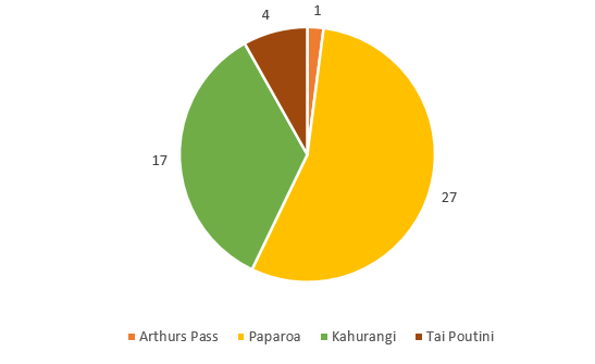
Kahurangi National Park (17 recommendations) |
|||
|
Assessment Area |
Protected Area Name |
NaPALIS id |
|
|
KAR_01 |
Conservation Area - Mossy Burn |
2807687 |
|
|
KAR_03 |
Conservation Area - Ōpārara |
2807684 |
|
|
KAR_10 |
Conservation Area - Kelly Creek (Remaining) |
2807709 |
|
|
KAR_10 |
Conservation Area - Kelly Creek (Pasture) |
2807709 |
|
|
KAR_13 |
Conservation Area - Arapito |
2807697 |
|
|
KAR_13 |
Conservation Area - Jordan Creek (Remaining) |
2807713 |
|
|
KAR_13 |
Conservation Area - Jordan Creek (Pasture) |
2807713 |
|
|
KAR_14 |
Conservation Area - Kongahu Swamp Road |
2807724 |
|
|
KAR_16 |
Conservation Area - Scobie Clearing |
2807711 |
|
|
KAR_17 |
Conservation Area - Little Wanganui River (North) |
2807700 |
|
|
KAR_17 |
Conservation Area - Little Wanganui River (South) |
2807723 |
|
|
KAR_19 |
Conservation Area - Lyell Range - Radiant Range (North) |
2807731 |
|
|
KAR_19 |
Conservation Area - Blue Duck Creek |
2807732 |
|
|
KAR_19 |
Conservation Area - Tidal Creek |
2807736 |
|
|
KAW_06 |
Conservation Area - Lyell Range - Radiant Range (Central) |
2807731 |
|
|
KAW_19 |
Conservation Area - Lyell Range - Radiant Range (South) |
2807731 |
|
|
KAW_19 |
Conservation Area – Newton River |
2807808 |
|
Paparoa National Park (27 recommendations) |
|||
|
Assessment Area |
Protected Area Name |
NaPALIS id |
|
|
PAP_02 |
Conservation Area - Ananui Creek |
2806955 |
|
|
PAP_02 |
Conservation Area - Northern Paparoa Range |
2808295 |
|
|
PAP_02 |
Conservation Area - Little Tōtara River |
2808369 |
|
|
PAP_06 |
Conservation Area - Basin Road |
2808292 |
|
|
PAP_06 |
Conservation Area - Nile River |
2808366 |
|
|
PAP_06 |
Conservation Area - Charleston |
2808367 |
|
|
PAP_07 |
Conservation Area - White Horse Creek |
2806939 |
|
|
PAP_07 |
Conservation Area - Four Mile River |
2808371 |
|
|
PAP_07 |
Conservation Area - Red Jacket Creek |
2808372 |
|
|
PAP_07 |
Conservation Area - Red Jacket Creek |
2808373 |
|
|
PAP_08 |
Conservation Area - Woodpecker Bay |
2808374 |
|
|
PAP_09 |
Conservation Area - Fox River |
2808375 |
|
|
PAP_10 |
Conservation Area - Bullock Creek Farm |
2808377 |
|
|
PAP_14 |
Conservation Area - Punakaiki River (Inland) |
2806886 |
|
|
PAP_14 |
Conservation Area - Punakaiki - Coast Road (South) |
2806891 |
|
|
PAP_18 |
Conservation Area - Barrytown - S.H.6 |
2806570 |
|
|
PAP_18 |
Conservation Area - Paparoa Range South |
2806778 |
|
|
PAP_18 |
Conservation Area - Barrytown |
2806783 |
|
|
PAP_18 |
Conservation Area - Baker Creek |
2806784 |
|
|
PAP_18 |
Conservation Area - Seventeen Mile Bluff |
2809052 |
|
|
INA_04 |
Conservation Area - Lower Buller Gorge Road |
2807826 |
|
|
INA_04 |
Conservation Area - White Cliffs |
2807842 |
|
|
INA_23 |
Conservation Area - Otututu Valley |
2806882 |
|
|
INA_23 |
Conservation Area - Mai Mai - Te Wharau (South) |
2806938 |
|
|
MAW_02 |
Conservation Area - Big River |
2806569 |
|
|
MAW_02 |
Pike Stream Conservation Area |
3446390 |
|
|
MAW_03 |
Conservation Area - Big River |
2806785 |
|
Arthur’s Pass (1 recommendation) |
|||
|
Assessment Area |
Protected Area Name |
NaPALIS id |
|
|
HOK_25 |
Ōtira River Conservation Area |
2806321 |
|
Westland Tai Poutini National Park (4 recommendations) |
|||
|
Assessment Area |
Protected Area Name |
NaPALIS id |
|
|
TWP_17 |
Conservation Area - Saltwater Forest |
2805646 |
|
|
TWP_26 |
Conservation Area - Waiho River |
2805305 |
|
|
TWP_28 |
Conservation Area - Docherty Creek |
2805310 |
|
|
TWP_28 |
Conservation Area - Waiho Flat |
2805312 |
|
- The NZCA agrees with and strongly supports all the above recommendations from the Western South Island National Panel, that these land parcels be added to existing National Parks.
- The NZCA’s review of the NPMPs for the West Coast revealed 12 parcels which are recommended for addition to the relevant national parks.
- The Kahurangi NPMP 2010 (Chapter 6: Administration) identifies one area for addition to the National Park. This is a block located near the Heaphy River Mouth, known as Whakapoai, which is currently part of the North West Nelson Forest Park. This is also identified in section 452 of the Ngāi Tahu Claims Settlement Act 1998 as an area to be added to Kahurangi. It is not part of the current stewardship land reclassification project, but should be considered at some later date.
- The Paparoa NPMP 2017 identifies five areas for inclusion within the Park. Three of these (Bullock Creek (PAP_10), Nile River and Charleston (PAP_06)) are recommended for addition by the National Panel, and are highlighted in the table above. The NPMP also recommends the addition of the Tiropahi Ecological Area (“to protect the significant caves in the area”), and the Inangahua Landing Scenic Reserve, between Ruff Creek and Yorke Creek (“to protect the outstanding values of the area”). They are not part of the current stewardship land reclassification project, but should be considered at some later date.
- The Westland Tai Poutini NPMP 2001 identifies six areas of high conservation value that should be considered for addition:
-
- North Waikukupa coastline
- Kahikatea forest remnants adjoining the Waiho River flats
- Gillespies Point and Omoaroa River flats
- The matai/totara forest to the south of Canavans Knob near Franz Josef/Waiau
- Alpine Lake Aata Puai and 3 Mile Lagoon
- Kahikatea Forests of Ohinetamatea and Hunts Beach.
- The Alpine Lake and 3 Mile Lagoon have already been included in the National Park, and the matai/totara forest to the south of Canavans Knob is included in the table above (TWP_28 as highlighted). The other areas are considered in the analysis below.
The NZCA has identified areas requiring reconsideration for addition to existing National Parks
- The NZCA has reviewed the recommendations produced by the National Panel for land parcels adjoining existing national parks, and carried out its own assessment, analysing whether those parcels of land should be reconsidered as additions to existing National Parks, or whether a different land classification would better suit a specific area given its features and characteristics.
- During its assessment the NZCA reviewed the related NPMPs, Conservation Value Reports (CVR) and Panels’ Recommendation Reports (PRR), and compared these to a document shared by the Department’s Stewardship Land Team, containing a process and criteria on how to categorise protected areas.
- The NZCA in this submission will identify the parcels of land requiring reconsideration, the classification it deems as more suitable, and the justification for its recommendation.
Kahurangi National Park area
KAR_09 – Elfin Bluff (#2807688)
National Panel recommendation: Scenic Reserve
Mana Whenua Panel recommendation: Neutral
The NZCA RECOMMENDS including this parcel of land as an addition to Kahurangi National Park.
- The NZCA does not agree with the Panel’s notion that the area, as a scenic reserve, would act as a ‘buffer’ to facilitate the preservation of the adjacent national park. The NZCA find that it would be more appropriate for the area to be added into the national park given its iconic landscape, scenic value, and naturalness.
KAR_18 – O’Connor Creek (#2807735), Boulder Creek (#28007737)
National Panel recommendation: Ecological Area (both)
Mana Whenua Panel recommendation: Neutral, Ecological Area
The NZCA RECOMMENDS including these parcels of land as additions to Kahurangi National Park, in alignment with the National Panel’s recommendation for the neighbouring Blue Duck Creek, Tidal Creek, and Lyell Range – Radiant Range land parcels (KAR_19).
- This would be line with the Panel’s rationalisation of grouping similar land parcels to improve the landscape continuity and connectivity. The NZCA believes this to be a suitable recommendation in terms of creating a mountain-to-sea environmental protected area.
Paparoa National Park area
MAW_16 – Eleven Mile Creek (#2809068), MAW_17-Ten Mile Creek / Wainaniwaniwa (#28009047), MAW_19-Nine Mile Creek / Kotorepi (#28009048)
National Panel recommendation: Scenic Reserve (all)
Mana Whenua Panel recommendation: Neutral (all)
The NZCA RECOMMENDS including these three parcels of land as additions to the Paparoa National Park.
- This is to give recognition to the high degree of naturalness in the area which contains freshwater ecosystems and catchments surrounded by original and secondary growth native forest. The NZCA also believes this addition would provide mountain-to-sea protection to allow for greater ecological diversity and biodiversity health in the area. The NZCA believes including all adjacent parcels of land into this recommendation would create a significant coastal corridor benefitting the area.
PAP_05 – Deep Creek (#2806767), Four Mile River (#2808365)
National Panel recommendation: Scenic Reserve (both)
Mana Whenua Panel recommendation: Neutral (both)
The NZCA RECOMMENDS including these parcels of land as additions to the Paparoa National Park, in alignment with the National Panel’s recommendation for the neighbouring, Charleston, Basin Road, and Nile River land parcels (PAP_06).
- The NZCA holds the view that greater recognition needs to be given to the range of distinct and iconic landscape and environmental features that are present in this area, which hosts an extensive range of aquatic and terrestrial wildlife. It is rational for this land parcel recommendation to align with that of the neighbouring land parcels.
Arthur’s Pass National Park area
MAW_09 – Orita-Kopara, Granville, Grey River/Māwheranui, Robinson River Forest (#28007465, #27007468, #2807469, #2807512, #2807517, #2954675, and #2807522)
National Panel recommendation: Tarahanga e Toru Historic Reserve (all)
Mana Whenua Panel recommendation: Tarahanga e Toru Historic Reserve (all)
The NZCA AGREES with both panels in their recommendation to classify these land parcels as an Historic Reserve, with the name Tarahanga e Toru Historic Reserve.
- These areas are of high conservation value in various aspects, hosting a range of nationally significant avifauna and includes the Tai Poutini Mt Te Kinga Predator Free project. The NZCA also acknowledges the cultural significance of this land to Poutini Ngāi Tahu, and finds this a suitable land classification for the area.
Westland Tai Poutini National Park area
HOK_19 –Wanganui/Ōtira Catchments (North and South), Hokitika River – Bluff Creek, Kawhaka Forest, Kokatahi Riverbed, Mathias Pass Road (#2806272, #2805715, #2805712, #2806159, and #2805713)
National Panel recommendation: Tarahanga e Toru Historic Reserve (Wanganui/Ōtira Catchments (North) and Kawhaka Forest), and Conservation Park (all remaining blocks).
Mana Whenua Panel recommendation: Tarahanga e Toru Historic Reserve (Wanganui/Ōtira Catchments (North) and Kawhaka Forest), and Neutral (all remaining blocks).
The NZCA AGREES with both panels’ recommendations to classify Wanganui/Ōtira Catchments (North) and Kawhaka Forest as an Historic Reserve, with the name Tarahanga e Toru Historic Reserve.
The NZCA AGREES with the recommendations to classify Wanganui/Ōtira Catchments (South) and Hokitika River – Bluff Creek, Kokatahi Riverbed, and Mathias Pass Road as a Conservation Park.
- The NZCA acknowledges the cultural significance of the Northern land parcels to Poutini Ngāi Tahu and finds an Historic Reserve to be suitable land classification for the area. The NZCA finds that while the Southern Land parcels contain varied vegetations and ecosystems, some of which are of high levels of naturalness, they are not distinct enough to amount to a national park classification.
TWP_05 – Waitangi Forest, Ōkārito Forks, Ferguson Creek, and Waitangitāhuna (#2805301, #2805302, #2805303, #2805654, #2809661, #2809662, and #2809665)
National Panel recommendation: Conservation Park (all)
Mana Whenua Panel recommendation: Neutral (all)
The NZCA RECOMMENDS including these parcels of land as additions to the Westland Tai Poutini National Park.
- The area contains extensive indigenous forest, semi-braided riverbeds, wetlands, extensive subalpine and high alpine vegetation. This hosts a broad range of forest birds and invertebrates. The NZCA notes that this area is substantially unique and should be given the appropriate land protection.
TWP_25 – Docherty Creek, Waiho River, Tatare Stream (#2805277, 2805278, 2805279, 2805304, 2805306, 2805311, and 2805313)
National Panel recommendation: Conservation Park (all)
Mana Whenua panel: Neutral (all)
The NZCA RECOMMENDS including these parcels of land as additions to the Westland Tai Poutini National Park
- Adding these parcels to the National Park aligns with section 4.5.1 of the Westland Tai Poutini NPMPs identification of the kahikatea forest adjoining the Waiho River flats as areas of high conservation value. It also realises the intent of section 6(j) of the General Policy for National Parks.
TWP_29 – Ōmoeroa River and Waikūkūpa River (#2805307 and #2805308)
National Panel recommendation: Local Purpose (River Conservation) Reserve (both)
Mana Whenua panel: Neutral (both)
The NZCA RECOMMENDS including these parcels of land as additions to the Westland Tai Poutini National Park
- Adding these parcels to the National Park aligns with section 4.5.1 of the the Westland Tai Poutini NPMPs identification of the North Waikūkūpa coastline and Ōmoeroa River flats as areas of high conservation value. It also realises the intent of section 6(j) of the General Policy for National Parks.
TWP_31 – Gillespies Beach (#2805316)
National Panel recommendation: Local Purpose (Waikōhai Ngāi Tahu) Reserve
Mana Whenua panel: Local Purpose (Waikōhai Ngāi Tahu) Reserve
The NZCA RECOMMENDS including this parcel of land as an addition to the Westland Tai Poutini National Park
- Adding this parcel to the National Park aligns with section 4.5.1 of the Westland Tai Poutini NPMPs identification of Gillespies Point as an area of high conservation value. It also realises the intent of section 6(j) of the General Policy for National Parks.
The NZCA has found that the Conservation Value Report and the Panels’ Recommendation Report for TWP_36 do not correlate
- The NZCA is concerned that there is significant disparity between the Conservation Value Report (CVR) and the Panels’ Recommendation Report (PRR) relating to assessment area TWP_36 – Cook River/Weheka to Haast River, Mahitahi Riverbed, Paringa Bridge, and Abbey Rocks, situated between the Westland Tai Poutini National Park and Mt Aspiring National Park. (See diagram here, PDF, 2,697K)
- The information included in the two reports shows differing assessment areas, identified in the images overleaf. There is a significant area of stewardship land that has been assessed and appears in the CVR, but has not been addressed in the PRR.
- There is a discrepancy of 47,063ha in the area of Cook River/Weheka to Haast River, with 188,710ha assessed in the CVR and only 141,647ha appearing in the PRR. In addition to this, the area of Sandy Beach – Jacobs River, an area of 11.2398ha, has not been addressed in the PRR.
- The NZCA wants to emphasise the need for consistency and accuracy in the delivery of information and resources for public consultation. The Department will need to provide clarification and further information on what the parameters are for this land parcel, to avoid confusion.
TWP_36 – Cook River/Weheka to Haast River, Mahitahi Riverbed, Paringa Bridge, Abbey Rocks, and Sandy Rocks – Jacobs River (#2804986, #2804993, #2804994, #2804997, and #2805008)
The NZCA STRONGLY RECOMMENDS that the identified land parcels within the assessment area and all other adjacent areas, should be classified as national parks, with additions made to both Westland Tai Poutini National Park and Mt Aspiring National Park.
- Adding this parcel to the National Park aligns with section 4.5.1 of the Westland Tai Poutini NPMP’s identification of the Kahikatea forests of Ohinetamatea and Hunts Beach, as areas of high conservation value.
- The primary justification for this recommendation is that the inclusion of these areas will create a complete mountain-to-sea environment, and the national park status will provide adequate protection for its highly valued, distinct, and diverse ecological characteristics. This as an appropriate measure to take in protecting the area’s unique landscape, vegetation, and ecosystems.
- The NZCA is also aware of the cultural significance these areas have to Poutini Ngāi Tahu and feels that any conflicts that arise regarding customary practices of mana whenua can be addressed and resolved through the current Conservation Law Reform process.
[1]Help us reclassify stewardship land on the West Coast: Have your say (doc.govt.nz)
[2] PCE Reports: Investigating the future of Conservation: The case of Stewardship Land (2013) and Update Report - Investigating the future of Conservation: The case of Stewardship Land (2015)