Redwoods alongside the Kiriwhakapapa Loop Track
Image:
Bev Bacon
| DOC
Kiriwhakapapa Loop
Located in Tararua Forest Park in the Wairarapa region
|
Introduction
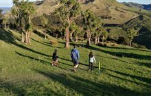
This loop walk passes through regenerated native forest - it's well-graded and suitable for children.2 km loop
Dog access
Dogs allowed. Keep dog under control at all times. Other pets on conservation land rules.
This well-graded walk passes through forest that has regenerated well after being logged for its rimu and other podocarp trees in the 1930s. Another attractive feature is the many planted redwoods.
It connects with a low-level tramping track that follows old bush tramlines through to the Mikimiki valley, and with a tramping track that ascends the Blue Range to the Blue Range Hut, approximately 2–3 hours away.
The loop is off the Blue Range Track at the end of Kiriwhakapapa Road, 7 km from State Highway 2, about 16 km north of Masterton.
Contacts
| Wellington/Kapiti information | |
| Phone: | +64 3 546 9339 |
| Email: | nelsonvc@doc.govt.nz |
| About: | Whakatū/Nelson Visitor Centre provides visitor information for this area |