Tongariro fires 2025
Two fires recently burned significant areas of Tongariro National Park, affecting the area around the start of the Tongariro Alpine Crossing. Visitors can expect to see blackened landscapes and burnt vegetation, but also regrowth as plants begin to recover.
Hapū Ngāti Hikairo ki Tongariro have placed a 10-year restorative rāhui over the affected area to protect the land while it recovers.
You can respect the rāhui and help recovery:
- Stay on the tracks, and do not enter the fire-affected areas off-track
- Clean your shoes and gear before visiting to prevent the spread of weeds into the area
- Take your rubbish home with you
For those wanting to contribute financially, the New Zealand Nature Fund is accepting donations that will support the ecological components of recovery.
Trek across volcanic alpine landscape of dramatic contrasts – steaming vents, glacial valleys, ancient lava flows, alpine vegetation and vivid crater lakes, all with stunning views.
Bookings are recommended for all visitors using any part of the Tongariro Alpine Crossing track. A track booking is needed to use a shuttle or guided walk service.
Book to use any part of the Tongariro Alpine Crossing.
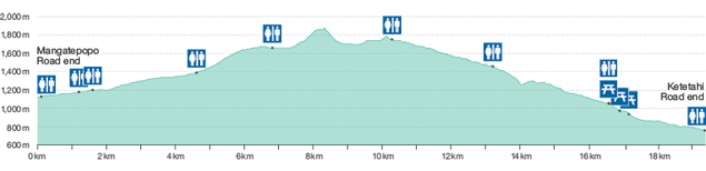
About the track
This challenging trip begins at 1120 m following a well-formed boardwalk in a gradual climb through the Mangatepōpō Valley. The initial 5.4 kilometres share the track with the Soda Springs Walk. Soda Springs Walk is an easy 2 hr return is a good option for those who may not have the fitness to attempt the more challenging parts of the crossing.
At the end of the valley the track increases in difficulty, with a steady climb of around 350 m up a staircase to a short plateau in South Crater.
The climb resumes with the ascent to Red Crater, the highest point in the Crossing at 1886 m.
A steep descent on volcanic rock scree brings walkers to the vivid Ngā Rotopounamu-Emerald Lakes.
Loose rocks and stones on the steep slopes of Red Crater present a major slip hazard. Walkers are advised to take extra time and care.
The track continues past Blue Lake - Te Wai Whakaata o Te Rangihīroa (Rangihīroa’s mirror) and begins the long descent of the Northern slopes. The zig-zag descent includes many steps which can present difficulties for those with weaker knees.
Enjoy the magnificent views over Lake Rotoaira and Lake Taupō before descending further into lush forest. The track ends at Ketetahi Road at an altitude of 760 m.
Be prepared for a long and challenging day out and be rewarded with stunning vistas and experiences.
Elevation profile
- Change in elevation: +/- 1196 m
Alternative walks
If conditions are poor, try alternatives such as Taranaki Falls Walking Track or Tama Lakes Track.
Care for Tongariro
Join Ngāti Hikairo ki Tongariro, the kaitiaki (guardians) of this sacred maunga, in protecting Tongariro for future generations. Be prepared, stay on the tracks and take care when you visit.
Understand if you are ready for the Tongariro Alpine Crossing
Watch the NZ Mountain Safety Council’s walk-through video which takes you through how to prepare for this track. Including facilities, key decision points, hazards and typical conditions for the area.