Te Puke (Te Pukeohikarua) Hut area hunting
Located in Hawke's Bay hunting in the Hawke’s Bay region
|
Introduction
Te Puke (Te Pukeohikarua) Hut is located in the upper central region of the Kaweka Forest Park at the southern end of the Te Pukeohikarua Tops. The climate here is subject to extreme variations.Species
- Deer - Red
- Deer - Sika
Permit requirements
This hunting area is covered by an 'open area permit' – get it online or from a DOC office.
Dog access
About this hunting block
Location
Te Puke Hut is located in the upper central region of the Kaweka Forest Park at the southern end of the Te Pukeohikarua Tops.
Access
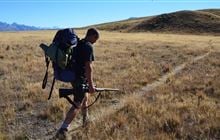
Te Puke Hut is ideally positioned to allow hunts in all directions, over varying types of terrain. As one of the park’s highest huts, the climate here is subject to extreme variations. The weather can also affect helicopter flying, and strong winds and/or poor visibility are not uncommon.
North by the open tops
From the hut helipad, follow the main track west towards the trig. A hunter’s track branches off to the north and you can follow this across the open tops for approximately 2 kilometres. Several ridges fall towards the west along this route and provide good access to hunting.
The immediate access to the east (headwaters of the Mangaturutu Stream) is steep.
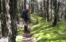
Hunters can reach a campsite (known as the ‘Te Puke exclosure’ site) by heading north along a forested ridge to the campsite helipad (2 hours walking time from Te Puke Hut). Many hunting opportunities are available along this route with good results often obtained north of the exclosure area down towards to Mangatainoka Hut.
By the southeast ridge track towards Mangaturutu Hut
From the helipad, follow the marked track towards Mangaturutu Hut. Via ridges and gullies on both sides the Mangaturutu catchment to the north or the Omarukokere (Omar) Stream to the south can be accessed.
Omar Tops to the South
The saddle between the Omar Tops and Te Puke trig can provide access to an excellent hunting area with open tops and beech forested gullies. Head south across the saddle. There are open tops stretching over 2 kilometres to the south, terminating amongst some very steep bluff country. Some good day hunts and fly-camping opportunities are available.
The southwest ridge down to Harkness Hut and the Pukeohikarua Stream (Herb’s Creek)
The Harkness Hut track drops steadily down a ridge heading southwest to spot height 1344 before bending northwest towards Harkness Hut. Good access to hunting opportunities is available both north and south of the track. On the northern side, tributaries of the Harkness (Ngaawapurua) Stream and associated gully heads are well worth a look. To the south provides access to the upper areas of Herbs Creek (Pukeohikarua Stream).
Making the best use of main tracks when planning a hunting adventure will help ensure a safe and easy return.
Dogs
Only registered, avian aversion certified hunting dogs, guide dogs, companion dogs (certified by the Top Dog Companion Trust) and dogs used for special services (including conservation management activities) are permitted in the park. All other dogs are banned.
Contacts
| Ahuriri / Napier Office | |
| Phone: | 0800 275 362 |
| Fax: | +64 4 471 1117 |
| Email: | napier@doc.govt.nz |
| Address: |
Level 2 Dunvegan House 215 Hastings Street Napier 4110 |
| Postal Address: |
PO Box 644 Napier 4140 |
| Full office details | |