Arthur's Pass East hunting
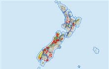
Located in North Canterbury & Arthur’s Pass hunting in the Canterbury region
|
Introduction
Arthur's Pass National Park straddles the main divide—the 'back bone' of the South Island—between Canterbury and the West Coast. Pigs, red deer and chamois are present.Species
- Chamois
- Deer - Red
- Pigs
Permit requirements
This hunting area is covered by an 'open area permit' – get it online or from a DOC office.
Dog access
About this hunting block
This information covers both Arthur's Pass East, and Arthur's Pass West and is repeated there.
General information
Arthur's Pass National Park straddles the main divide - the 'back bone' of the South Island - between Canterbury and the West Coast.
Containing high mountains with large scree slopes, steep gorges and wide braided rivers, the park (114,400 ha) has been divided into two hunting areas - east and west.
Pigs, red deer and chamois are present in low to moderate numbers and populations can be quite localised.
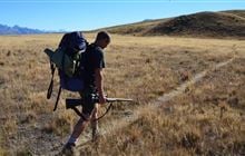
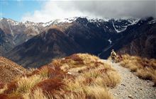
The terrain varies from moderate to very steep. The vegetation is beech forest, riparian shrublands with alpine shrublands, tussock, rock and scree tops.
Areas excluded from hunting are: all road corridors (e.g. SH73); Arthur's Pass and Ōtira villages; Mt White Station land on the eastern borders, Taramakau riverbed and the Waimakariri riverbed downstream of the Bealey Bridge.
Please note your Canterbury hunting permit also covers the section of Arthur's Pass that is managed by the West Coast. Should you wish hunt outside the park boundaries on the West Coast side, you will require a West Coast hunting permit. For further information contact the local DOC office.
Note: this is an alpine area near the main divide and rivers can rise very quickly so take care with river crossings. Other hunters and trampers may be encountered. Take precautions and identify your target.
Access
There are many access points along SH73, via tramping tracks that start at roadside or road end car parks or via major rivers. On the west of the main divide these include Kellys and Goat creeks, Ōtira, Taramakau and Rolleston rivers.
Access into the Deception and Taramakau is from Aickens corner or the Morrison footbridge.
In the east, access to the Mingha and Edwards valleys is from Greyneys Shelter. The upper Waimakariri valley can be accessed via Waimakariri River from Klondyke Corner, or Bealey Spur.
The Hawdon, Andrews and Poulter valleys, and the Binser Saddle tracks are all accessed from the Mt White Road.
Vehicles are not permitted off-road in the national park.
Landholders
The above public access routes do not require any landholder permission.
Map information
NZTopo50 maps BU20, BU21, BV21.
NewTopo Arthur's Pass map.
Dogs
Dogs are not permitted in any national park.
Huts
West hunting area
Serviced huts:
Standard huts:
- Crow Hut
- Anti Crow Hut
- Barker Hut
- Carroll Hut
Basic huts and bivs
East hunting area
Serviced huts:
Standard huts:
Basic huts and bivvies:
- Upper Deception Hut
- Bull Creek Hut
- Sudden Valley Bivvy
- East Hawdon Bivvy
- Pfeifer Bivvy
- Minchin Bivvy
- Mingha Bivvy
- Poulter Bivvy
- Ranger Bivvy
- Worsley Bivvy
Additional information
Hunters are advised to check for current pesticide operations that may be in progress where they intend to hunt.
Contacts
| Arthur's Pass National Park Visitor Centre | |
|---|---|
| Phone | +64 3 318 9211 |
| arthurspassvc@doc.govt.nz | |
| Address | 104 West Coast Road Arthur's Pass 7654 |
| Hours | See visitor centre hours |