History and culture of Fiordland National Park
Introduction
Fiordland National Park was officially constituted in 1952. Today it covers over 1.2 million hectares and was declared a World Heritage Area in 1986.Fiordland National Park was officially constituted in 1952. Today it covers over 1.2 million hectares and was declared a World Heritage Area in 1986.
Te Rua-o-Te-Moko
Fiordland was well known to the Māori, and many legends recount its formation and naming. Demigod Tuterakiwhanoa is said to have carved the rugged landscape from formless rock.
Few Māori were permanent residents of the region but seasonal food-gathering camps were linked by well worn trails. Takiwai, a translucent greenstone, was sought from Anita Bay and elsewhere near the mouth of Milford Sound/Piopiotahi.
First Europeans
Captain Cook and his crew were the first Europeans to visit Fiordland, and in 1773 spent five weeks in Tamatea/Dusky Sound. Cook’s maps and descriptions soon attracted sealers and whalers who formed the first European settlements of New Zealand. From the middle of the 19th century surveyors, explorers and prospectors began to penetrate the unexplored interior of Fiordland.
Preservation Inlet boomed briefly in the 1890s after gold was found, but efforts to establish mines, timber mills and farms in Fiordland have generally been short-lived.

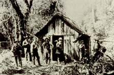
Original Beech Hut near the present site of Quintin Lodge on the Milford Track
Early settlers
Quintin McKinnon and Donald Sutherland opened up the Milford Track in 1889 and began guiding tourists through the now world-famous route. Richard Henry, one of the pioneers of threatened species work transferred kākāpō and kiwi to islands in Tamatea/Dusky Sound in the late 1890s and early 1900s.
