
Opito Point Pā
Introduction
The pā at Opito Point is a good example of a medium sized headland pa. It occupies the whole of the point at the eastern end of the Kūaotunu Peninsula.Like most headland pā, the site relied on the steep cliffs of the headland to thwart attackers.
Much of the earthworks remain intact and are clearly visible.
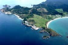
From the air: the pā site is on the tip of the headland right of centre. The steep cliffs acted as formidable defences
These include four defensive ditches, numerous pits, and terraces. Explore the impressive earthworks while taking in the magnificent views of the Mercury Islands and Opito Bay – a beautiful white sandy beach typical of the Coromandel Peninsula.
Getting there
The site is off SH25 between Coromandel Township and Whitianga. At Kūaotunu take the sign posted turn to Otama Bay and Opito Bay down Black Jack Road. Follow this unsealed road to the car pārk at Opito Bay. The site is a 10 minute walk along the beach from the car pārk.
Access on to the pā is via a staircase-track at the east end of Opito beach. More about the track to this pā.
Dog access
Dog access changes seasonally – follow the council signs that are on the beach and accessways to the beach.
| Kauaeranga Visitor Centre | |
| Phone: | +64 7 867 9080 |
| Fax: | +64 4 471 1117 |
| Email: | kauaerangavc@doc.govt.nz |
| Address: |
995C Kauaeranga Valley Road Thames 3577 |
| Postal Address: |
PO Box 343 Thames 3540 |
| Full office details | |