- Wood burner for cooking
- Bench top
- Axe, shovel and broom
- Long drop style toilet
- Table and seating
- Stream water supply
- Meat safe
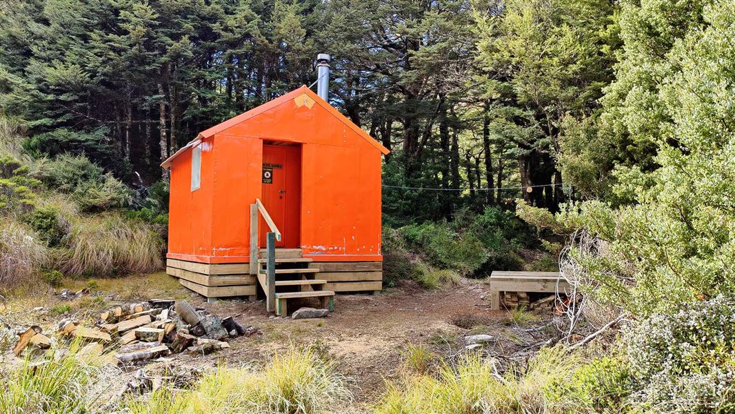
Studholme Saddle Hut is located on the western side of the main Kaweka Range, south of Kaweka J.
Studholme Saddle Hut was built in 1969 by the New Zealand Forest Service, the hut was relocated to its current location in April 2024.
It is 1240 metres in altitude situated in a tributary of Kiwi Creek and is surrounded by beech forest. The area is subject to strong winds and adverse weather conditions common to high altitude sites.
Fees
- Adult (18+ years): $10 per night
- Youth (5–17 years): $5 per night
- Child/Infant (0–4 years): free
Bookings aren't required. But before you go, buy 1 Standard Hut Ticket (blue for adults, yellow for youth) for each night's stay. Put this in the honesty box at the hut. Or buy a Backcountry Hut Pass that gives unlimited use at most Standard and Serviced huts for a 12 month period.
About hut tickets and passes | Retailers that sell hut tickets and passes
Walking
Makahu Saddle Carpark (3 hr)
The hut is reached from the north by travelling southwards from Kaweka J from the Makahu Saddle Roadend.
Mackintosh Carpark (5 – 6 hr)
Studholme Saddle Hut can be reached from the south from the Mackintosh Carpark via Mackintosh Track. This is an 8 kilometre walk.
Other routes:
- Cameron Carpark via Kiwi Saddle Hut (7 – 7.5 hours; 15 kilometres)
- Lakes Carpark over the Rogue Ridge route (3 – 4 hours). Look out for the turn off to the bivouac. For experienced trampers only.
Tramping
Studholme Saddle Hut is ideally located for a weekend or the start of an extended tramp. There are many options available to travel in any direction:
- From the hut, head over to Manson Country in the west via Back Ridge and Rocks Ahead Huts.
- Or head north along the Kaweka Ridge to Whetu (1650 metres) and onwards to Middle Hill or Makino Huts.
- Head east via Kaweka J and down to Makahu Saddle Hut at the Makahu Saddle Roadend.
Trampers are reminded that a number of the tracks in and out of the Kaweka Ridge or Back Ridge areas are via poled routes traversing open Kaweka sub-alpine tops between 1300 – 1700 metres altitude – caution may be required during adverse weather conditions. Wind speeds exceeding 180 kmh are not uncommon over the main tops, along with extremely cold conditions at any time of the year.
Kaweka Forest Park access conditions
We recommend 4WD vehicles to reduce wear on the road and safe travel.
- Lotkow Road: The river crossings are regularly changing, check before crossing.
- Lakes carpark is accessible via Kuripapango road. The previous access Castle Rock road is now closed due to ongoing forestry operations.
- Lawrence Carpark access road: The last 600 m of the road is steep and not recommended for 2WD vehicles - a parking space is available before the descent. The Lawrence swing bridge has been removed.
- Mackintosh car park is currently closed due to ongoing forestry operations. A new parking location can be located at a skid site near the closed gate (end of Kuripapango Road), this will add on 500 m walking to reach the start of the track.
- Whittle Road: Be aware of trucks using the quarry. Give them right of way where possible.
Location
NZTopo50 map sheet: BJ37
Grid/NZTM2000 coordinates: E1890017 N5643903
Communication
Excellent coverage with HF / Mountain Safety radios is available at the hut site. Cell phone service (analogue) can usually be received from the ridge top.
DOC Customer Service Centre
| Phone: | 0800 275 362 |
| Email: | napier@doc.govt.nz |
| Address: | Ahuriri / Napier Office |